Map of Central America : including the states of...


 Mapas, planos y cartas náuticas
Map of Central America : including the states of Guatemala, Salvador, Honduras, Nicaragua & Costa Rica, the... (1856)
Mapas, planos y cartas náuticas
Map of Central America : including the states of Guatemala, Salvador, Honduras, Nicaragua & Costa Rica, the... (1856)
 Disponible Ejemplares
 Sección: Mapas, planos y cartas náuticas
Título uniforme: AMERICA CENTRAL. Mapas generales (1856). 1:2100000
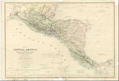
Título: Map of Central America : including the states of Guatemala, Salvador, Honduras, Nicaragua & Costa Rica, the territories of Belise & Mosquito, with parts of Mexico, Yucatan & New Granada : shewing the routes between the Atlantic & Pacific Oceans by way of Tehuantepeque, Nicaragua & Panama / Edited by Trelawney Saunders F.R.G.S. From the original Drawing of John Baily Esqr. R.M. of Guatemala ; with Additions from the latest surveys of the Admiralty S. Moro... [et al.] & other documents ; the Railway Surveys in Honduras contributed by the Hon. E.G. Squier formerly Chargé d'Affaires of the United States to the Republics of Central America
Área de datos: Escala [ca. 1:2100000 ; proy. Mercator] (O 96°00'--O 79°00'/N 18°30'--N 7°00')
Publicación: London : Edward Stangard, 6 Charing Cross, 1856
Descripción física: 1 mapa : col. ; 64 x 94 cm
Tipo de contenido: Imagen cartográfica
Tipo de medio: computadora
Tipo de soporte: recurso en línea
Notas: Hay una edición anterior de 1853 con signatura SGE J-4-1-17 (a)
Esala gráfica de 200 millas geográficas de 60 en grado [= 17'6 cm], de 200 millas estatuarias [= 15'3 cm] y 70 leguas de Castilla [= 14'1 cm]. Red geográfica de 1° en 1°
Relieve representado con normales y puntos acotados expresados en pies
Figuran diversas notas sobre los conflictos relacionados con el establecimiento de las fronteras (especialmente entre Costa Rica y Nueva Granada) y una relativa a la diferencia de nivel entre ambos oceános
Cinco gráficos muestran los perfiles longitudinales del terreno existente entre el lago Nicaragua y el océano Pacífico, o bien entre éste y el océano Atlántico y correspondientes a rutas de navegación ejecutadas por diverssos geógrafos, con el nombre de éstos y fecha del reconocimiento. Los perfiles son los siguientes: Lago Nicaragua-Lago de Managua-Realejo; Lago Nicaragua-Río Sapoa-Océano Pacífico; Canal de Panamá; Puerto de San Juan de Nicaragua-Lago Nicaragua-Puerto de San Juan; Bahía de Honduras-Bahía de Fonseca. Su recorrido se encuentra marcado sobre el plano. En todos ellos se indica la altura de las aguas y del terreno y distancias
Paises diferenciados por colores
Procede de la colección Coello
Materia / lugar / evento: Navegación marítima
Mapas generales
Perfiles
Otros autores: Baily, John
Saunders, Trelawney
Moro, S
Squier, E.G
Stanford, Edward
CDU: 912:656.61]:744.4(728)"1856"
728
Tipo de publicación:
Mapas
Derechos:
Préstamo:
Disponible
