Map Illustranting the Military Operations in front of...


 Mapas, planos y cartas náuticas
Map Illustranting the Military Operations in front of Atlanta Ga. : From the passage of Peach Tree Creek, July 19... (1875)
Mapas, planos y cartas náuticas
Map Illustranting the Military Operations in front of Atlanta Ga. : From the passage of Peach Tree Creek, July 19... (1875)
 Disponible Ejemplares
 Sección: Mapas, planos y cartas náuticas
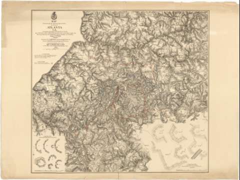
Título: Map Illustranting the Military Operations in front of Atlanta Ga. : From the passage of Peach Tree Creek, July 19 th. 1864, to the commencement of the movement upon the Enemy's lines of communication, South of Atlanta August 26 th. 1864 / Compiled by Athority of the Hon. The Secretary of War in the Office of the Chief of Engineers, U.S.A. 1875
Área de datos: [Ca. 1:32000]
Publicación: New York : Am. Photo-Lith° (Osbornes Process), 1875
Descripción física: 1 mapa : col. ; 70 x 76 cm
Tipo de contenido: Imagen cartográfica
Tipo de medio: computadora
Tipo de soporte: recurso en línea
Notas: Representa la ciudad y sus alrededores, indicando la posición que ocuparon en dicha zona los contendientes en la Guerra de Secesión (línea roja para los confederados y azul para las tropas federales)
Presenta la relación de mapas, con el nombre de sus respectivos autores, que han servido de base para la formación de éste
Bajo el título: "Maj. Gen'l W.T. Sherman, commanding U.S. Forces. Gen'l. J.B. Hood, commanding Confdte. Forces"
Escala gráfica de 1 milla [= 5 cm]
Relieve representado por normales
Inserta: "A portion of the Confederate Defenses of Atlanta". [Ca. 1:970], 400 pies [= 11,5 cm]. Consta de 7 plantas de fortificaciones. Orientado con flecha ; "A portion of the U.S. Defensive Works Erected after the capture of Atlanta". [Ca. 1:880], 400 pies [= 12,6 cm]. Consta de 6 plantas de fuertes. Orientado con flecha
Materia / lugar / evento: Operaciones bélicas
Mapas topográficos
Fortificaciones
Estrategia militar
1864
Georgia (Estados Unidos)
Estados Unidos
Otros autores: Estados Unidos. War Department
Estados Unidos. Army. Office of the Chief of Engineers
American Photo-Litographic (Nueva York)
CDU: 912:355.4:335.43:623.1(758 Atlanta)"1864"
758 Atlanta
Tipo de publicación:
Mapas
Derechos:
Préstamo:
Disponible
