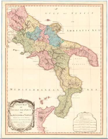
A new map of Sicily the first or the Kingdom of Naples...


 Disponible Ejemplares
 Sección: Mapas, planos y cartas náuticas
Título uniforme: Italia. Mapas generales. 1:1000000 (1794)
Título: A new map of Sicily the first or the Kingdom of Naples... / Engraved by B. Baker
Área de datos: Escala [ca. 1:1000000], 25 Common Leagues of France 25 to a Degree [= 11 cm]
Publicación: London : Laurie and Whittle 53, Fleet Street, 1794
Descripción física: 1 mapa : col. ; 69,5x53,3 cm
Notas: Escalas gráficas de 60 'Common Miles of Italy' [= 11 cm], 75 'Common Roman Miles' [= 11 cm], 65 'English Statute Miles' [= 11 cm]. Coordenadas referidas al meridiano de Londres (E13°10'-E18°30'/N42°55'-N37°). Red geografica de 1° en 1°
Relieve representado por sombreado
Tabla de signos convencionales para indicar los principales nucleos de población, arzobispados, obispados y castillos
Titulo enmarcado en cartela con motivos vegetales
ITL
Materia / lugar / evento: Mapas generales
Divisiones administrativas
1794
Otros autores: Baker, Benjamin, fl. 1780-1824
Robert Laurie and James Whittle
CDU: 912(45-13)'1794'
45-13
Tipo de publicación:
 Mapas
Mapas
Derechos:
Préstamo:
Disponible
