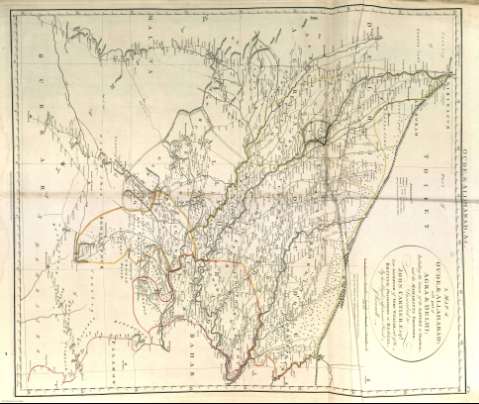
A map of Oude & Allahabad with part of Agra & Delhi :...


 Mapas, planos y cartas náuticas
A map of Oude & Allahabad with part of Agra & Delhi : including the course of the Ganges to Hurdwar; and the...
- Rennell, James, 1742-1830
Mapas, planos y cartas náuticas
A map of Oude & Allahabad with part of Agra & Delhi : including the course of the Ganges to Hurdwar; and the...
- Rennell, James, 1742-1830
Sección: Mapas, planos y cartas náuticas
Título: A map of Oude & Allahabad with part of Agra & Delhi : including the course of the Ganges to Hurdwar; and the Maharatta frontier / cInscribed to John Cartier Esqr., Late Governor of the Fort William, and of the British Possessions in Bengal, By his obliged, & affectionate friend J. Rennell ; W. Harrison fc.
Autor: Rennell, James, 1742-1830
Área de datos: Escala [ca. 1:1.504.065]. 100 Millas Inglesas [= 10'6 cm]
Descripción física: 1 mapa : col. ; 68 x 57 cm
Tipo de contenido: Imagen cartográfica
Tipo de medio: computadora
Tipo de soporte: recurso en línea
Notas: En el ángulo superior derecho: Nº X
Orientado con lis
Márgenes graduados
En el margen superior se dan las longitudes referidas al meridiano de: Greenwich y en el inferior las referidas al de: Calcutta
Relieve por montes de perfil y sombreado
Red hidrográfica y de caminos
Arbolado
Clave por símbolos
Representación de ciudades y fortificaciones
En el margen superior: "Oude, & Allahabad, & c."
Copia digital. Madrid : Copia digital, 2010
Registros relacionados: En: A Bengal atlas : containing maps of the theatre of war and commerce on that side of Hindoostan. - Inglaterra : [Editor no identificado], 1780. - [Lám. 10]
Materia / lugar / evento: Mapas generales
Núcleos de población
Navegación
Rutas comerciales
Montañas
Ríos
1780
India
Otros autores: Harrison, William
Títulos secundarios: Allahabad (India) (Provincia). Mapas generales. 1780
Agra (India) (Provincia). Mapas generales. 1780
Delhi (India) (Provincia). Mapas generales. 1780
CDU: (540.23)"1779"
(540.27)"1779"
Tipo de publicación:
Mapas
Derechos:
