The low countries beyond the Ganges from the Mauldah...


 Mapas, planos y cartas náuticas
The low countries beyond the Ganges from the Mauldah river to Silhet : comprending the midland and eastern inland...
- Rennell, James, 1742-1830
Mapas, planos y cartas náuticas
The low countries beyond the Ganges from the Mauldah river to Silhet : comprending the midland and eastern inland...
- Rennell, James, 1742-1830
Sección: Mapas, planos y cartas náuticas
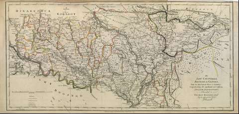
Título: The low countries beyond the Ganges from the Mauldah river to Silhet : comprending the midland and eastern inland navigation / Inscribed to Thomas Kelsall Esqr. By his affectionate Friend J. Rennell ; W. Harrison sc.
Autor: Rennell, James, 1742-1830
Área de datos: Escala [ca. 1:748.534]. 40 Millas Inglesas [= 8'6 cm]
Descripción física: 1 mapa : col. ; 32 x 66 cm
Tipo de contenido: Imagen cartográfica
Tipo de medio: computadora
Tipo de soporte: recurso en línea
Notas: Clave numérica
Orientado con lis
Márgenes graduados
Meridiano de origen: Calcuta
Relieve por montes de perfil y sombreado
Red hidrográfica y de caminos
Arbolado
Divisiones administrativas diferencidas por color
Toponimia abuntante
Copia digital. Madrid : Ministerio de Cultura, 2010
Registros relacionados: En: A Bengal atlas : containing maps of the theatre of war and commerce on that side of Hindoostan. - Inglaterra : [Editor no identificado], 1780. - [Lám. 6]
Materia / lugar / evento: Mapas generales
Núcleos de población
Navegación
Rutas comerciales
Montañas
Ríos
1780
India
Ganges (Río)
Otros autores: Harrison, William
Títulos secundarios: Dacca (India) (Bengala). Mapas generales. 1779
CDU: (540)"1779"
Tipo de publicación:
Mapas
Derechos:
