A New and Correct Map of the Province of Quebec with the...


 Mapas, planos y cartas náuticas
A New and Correct Map of the Province of Quebec with the Adjacent States and Provinces (1788)
Mapas, planos y cartas náuticas
A New and Correct Map of the Province of Quebec with the Adjacent States and Provinces (1788)
 Disponible Ejemplares
 Sección: Mapas, planos y cartas náuticas
Título uniforme: QUEBEC (Canadá) (Provincia). Mapas generales (1788). 1:740740
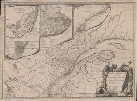
Título: A New and Correct Map of the Province of Quebec with the Adjacent States and Provinces / From the French Surveys, Connected with those made by Captain Carver, and other officiers, in His Majesty's Service
Área de datos: Escala [ca. 1:740.740] ( (O 81°40'-O 59°15'/N 53°30'-N 44°20')
Publicación: London, No. 53 Fleet Street : Printed for Robert Sayer, 1788
Descripción física: 1 mapa : col. ; 49 x 67 cm
Tipo de contenido: Imagen cartográfica
Tipo de medio: computadora
Tipo de soporte: recurso en línea
Notas: Escala gráfica expresada también en millas inglesas y leguas canadienses de dos millas
Relieve de perfil
Coloreado en tinta roja, amarilla y verde
En el ángulo inferior derecho grabado decorativo conteniendo título, autor y datos de publicación
Inserta: "Mapa de la Isla de Montreal e Isla Jesús en el curso del Río San Lorenzo". Escala gráfica en leguas marinas [ca. 1:36132]; "Plano dela ciudad de Quebec y alrededores". Escala gráfica expresada en pies ingleses; "Mapa parcial del curso del Río San Lorenzo". Escala gráfica expresada en millas inglesas [ca. 1:1102292]; "Plano de la ciudad de Montreal". Escala gráfica expresada en yardas inglesas
Materia / lugar / evento: Mapas generales
Divisiones administrativas
Quebec
Canadá
Otros autores: Carver, Jonathan, 1710-1780
Sayer, Robert, 1725-1794
CDU: 912(71-11-2/-5)"1788"
71-11-2/-5
Tipo de publicación:
Mapas
Derechos:
Préstamo:
Disponible
