Military Map of Middle Tennessee and parts of East...


 Mapas, planos y cartas náuticas
Military Map of Middle Tennessee and parts of East Tennessee and the Adjoining States benig of the Department of the... (1874)
Mapas, planos y cartas náuticas
Military Map of Middle Tennessee and parts of East Tennessee and the Adjoining States benig of the Department of the... (1874)
 Disponible Ejemplares
 Sección: Mapas, planos y cartas náuticas
Título uniforme: TENNESSEE (Estados Unidos). Mapas generales. 1874. 1:342414 (1865)
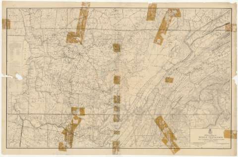
Título: Military Map of Middle Tennessee and parts of East Tennessee and the Adjoining States benig of the Department of the Cumberland / comanded by Maj. Gen. Geo. H. Thomas U.S.A. ; compiled and drawn under the direction of Col. W. M. E. Merrill, Ast. U.S.V.V. Eng'rs. Capt. Corps of Eng's. & Chief Engr. Dept. of the Cumberland, with the assistance of Prof. J. M. Safford, late State Geologist of Tennessee by C. S. Mergell, Asst. Engr. 1865
Área de datos: Escala [ca. 1:342414], 10 statute miles [= 4'7 cm] (O 88°30'--O 83°30'/N 37°00'--N 34°30')
Publicación: [Washington] : Published by Authourity of the Hon. Secretary ofWar in the Office of the Chief of Engineers, U.S.A. Army, 1874
Descripción física: 1 mapa ; 88 x 138 cm
Tipo de contenido: Imagen cartográfica
Tipo de medio: computadora
Tipo de soporte: recurso en línea
Notas: Comprende el estado de Tennessee y la parte septentrional de los de Alabama y Georgia, en los Estados Unidos
Relieve por normales
Tabla de signos convencionales para indicar los núcleos de población de distinta categoría y otros puntos de interés de la zona
En nota, se señalan todos aquellos trabajos tenidos en cuenta para la elaboración del presente documento
Materia / lugar / evento: Mapas generales
Divisiones administrativas
1874
Alabama
Georgia (Estados Unidos)
Estados Unidos
Otros autores: Thomas, G. H
Safford, J. M
Mergell, C. S
Merrill, W. E
Estados Unidos. Army. Office of the Chief of Engineers
CDU: 768
761-17
758-17
Tipo de publicación:
Mapas
Derechos:
Préstamo:
Disponible
