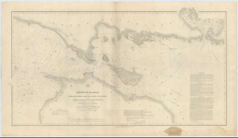
Straits of MacKinac with the Approaches there to from...


 Mapas, planos y cartas náuticas
Straits of MacKinac with the Approaches there to from Lakes Huron and Michigan and the Entrance by the Detour... (1874)
Mapas, planos y cartas náuticas
Straits of MacKinac with the Approaches there to from Lakes Huron and Michigan and the Entrance by the Detour... (1874)
 Disponible Ejemplares
 Sección: Mapas, planos y cartas náuticas
Título uniforme: MACKINAC (Estados Unidos) (Estrecho). Cartas náuticas. 1874 (1849-1856). 1:120000
Título: Straits of MacKinac with the Approaches there to from Lakes Huron and Michigan and the Entrance by the Detour Passage to the St. Mary's River / From trigonometrical Surveys under the direction of the topographical Bureau of the War Department... under the orders of Lieut. Col. James Kearney Topographical Engineers in 1849 and of Capt. J.N. Macomb corps Topl. Engrs. in 51, 1852, 1853 & 1854 ; Drawn by A. Boschke ; Engr, by Selmar Siebert
Edición: Ed. 1856, rev. 1874
Área de datos: Escala 1:120000 (O 85°14'--O 83°40'/N 46°6'--N 45°31')
Publicación: [Washington] : Topographical Bureau of the War Department, 1874
Descripción física: 1 carta náutica ; 55 x 102 cm
Tipo de contenido: Imagen cartográfica
Tipo de medio: computadora
Tipo de soporte: recurso en línea
Serie: (Survey of the Northern and North Western Lakes)
Notas: Escala también dada en formas gráficas de 10 millas comunes y 20000 yardas. Orientado con dos nudos de treintaidos rumbos. Mención de la variación magnética en diversos puntos
Relieve por normales
Indica sondas, batimétricas y faros
Clave hidrográfica para determinar la calidad del fondo
Tablas que recogen por un lado las variaciones en el nivel del mar y por otro la naturaleza de los faros
En nota se explica las características de navegabilidad en el estrecho de Mackinac y en los Lagos Michigan y Huron
Materia / lugar / evento: Cartas náuticas
Batimetría
Estrechos
1874
Otros autores: Kearney, James
Macomb, J. N
Boschke, A
Siebert, Selmar
Estados Unidos. War Department. Engineer Bureau
CDU: 774-17
Tipo de publicación:
Mapas
Derechos:
Préstamo:
Disponible
