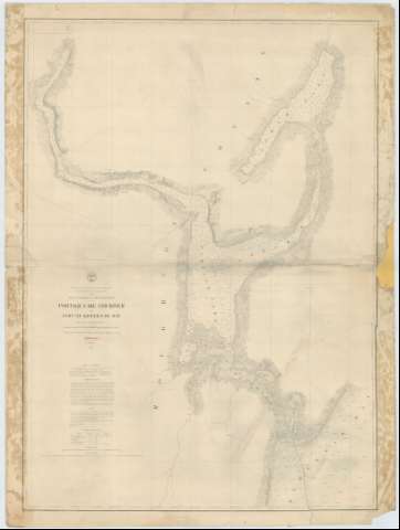
Portage lake and River with part of Keweenaw Bay


 Disponible Ejemplares
 Sección: Mapas, planos y cartas náuticas
Título: Portage lake and River with part of Keweenaw Bay / Projected from a Trigonometrical Survey executed under the orders of Col. J.D. Graham Corps of Engineers in 1863 and of Col. W.F. Raynolds A.D.C. and Major of Engineers in 1864 ; Published in 1865, Made in obedience to acts of congress and under the direction of the Bureau of Engineers of the War Department ; Drawn by J.U. Mueller ; Engraved by W.H. Dougal
Área de datos: Escala 1:30000 (O 88°38'15''--O 08°20'45''/N 47°12'50''--N 47°56'30'')
Publicación: [Washington] : Bureau of Topographical Engineers of the War Department, 1865
Descripción física: 1 carta náutica ; 100 x 74 cm
Tipo de contenido: Imagen cartográfica
Tipo de medio: computadora
Tipo de soporte: recurso en línea
Serie: (Survey of the Northern and North Western Lakes)
Notas: Escala también dada en formas gráficas de 3000 yardas y 3 millas legales inglesas. Orientado con tres nudos de rumbos, en los que se señala además la variación magnética observada
Relieve por normales
Indica sondas batimétricas y veriles, así como las líneas de derrota a seguir para recorrer la baía
Clave hidrográfica para determinar la calidad del fondo
En nota se informa sobre las características de la zona representada
En nota se señalan todos aquellos trabajos tenidos en mente para la elaboración del presente documento
Materia / lugar / evento: Cartas náuticas
Batimetría
Bahías
1864
Otros autores: Graham, James Duncan
Dougal, W. H
Raynolds, W. F
Mueller, J. U
Estados Unidos. War Department. Engineer Bureau
CDU: 774-16
Tipo de publicación:
 Mapas
Mapas
Derechos:
Préstamo:
Disponible
