Map Prepared to exhibit the Campaigns in which the Army...


 Mapas, planos y cartas náuticas
Map Prepared to exhibit the Campaigns in which the Army of the Cumberland took part during the war of the rebellion (189-?)
Mapas, planos y cartas náuticas
Map Prepared to exhibit the Campaigns in which the Army of the Cumberland took part during the war of the rebellion (189-?)
 Disponible Ejemplares
 Sección: Mapas, planos y cartas náuticas
Título uniforme: Estados Unidos. Geografía militar. 189. 1:1749272 (1861-1865)
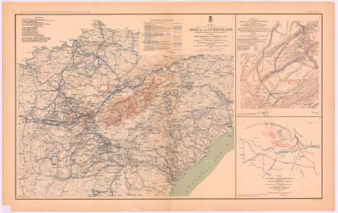
Título: Map Prepared to exhibit the Campaigns in which the Army of the Cumberland took part during the war of the rebellion / by order of Maj. Gen. Geo. H. Thomas, U.S.A. ; compiled under the direction of But. Maj. Gen. Z.B. Tower, Chief Engr. Milit. Div. of the tenn. ; by Ed. Ruger, Supt. Top'l Engr. Office at Nashville ; assistants Capt. A. Kilp and lieut R. Flach, 3rd U.S.C.A. (Heavy) and Asst. top. Engrs.
Área de datos: Escala [ca. 1:1749272], 50 mile [= 4'6 cm]
Publicación: Washington : Government Printing Office, [189-?] (N.Y. [Nueva York] : Julius Bien & co.)
Descripción física: 1 mapa : col. ; 51x60 cm, en h. de 47x75 cm
Tipo de contenido: Imagen cartográfica
Tipo de medio: computadora
Tipo de soporte: recurso en línea
Notas: En : Atlas to accompany the Official Records of the Union and Confederate Armies 1861 - 1865. - Plate CXVIII, n 1
Relieve : lineas perpendiculares normales
Figura leyenda de autoridades
Leyenda de simbolos explicando posicion y movimiento de las tropas de cada General y de cada división
Figura en margen inferior : 'General map'
Representadas mediante distinto color las posiciones del ejercito federal y confederado
En : . Atlas to accompany the Official Records of the Union and Confederate Armies 1861 - 1865
Materia / lugar / evento: Guerra civil
Mapas militares
Itinerarios
Maniobras de campaña
S.XIX
Estados Unidos
Otros autores: Tower, Z. B
Ruger, Edward
Kilp, A
Flach, R
CDU: 912:355.4]:[656.02+355.52](73-11)'1861/1865'
912:355(73-11)'1861/1865'
73-11
Tipo de publicación:
Mapas
Derechos:
Préstamo:
Disponible
