Campaign maps (numbers 1 to 11 inclusive) showing...


 Mapas, planos y cartas náuticas
Campaign maps (numbers 1 to 11 inclusive) showing position of 20 th. Army Corps on march from Atlanta, Ga., to... (189-?)
Mapas, planos y cartas náuticas
Campaign maps (numbers 1 to 11 inclusive) showing position of 20 th. Army Corps on march from Atlanta, Ga., to... (189-?)
 Disponible Ejemplares
 Sección: Mapas, planos y cartas náuticas
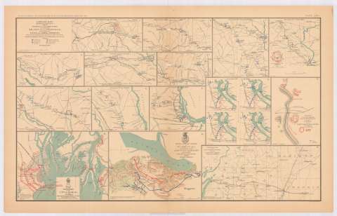
Título: Campaign maps (numbers 1 to 11 inclusive) showing position of 20 th. Army Corps on march from Atlanta, Ga., to Savannah, Ga. : with dates and Union and Rebel defenses : December, 1864 / from Surveys of Topographical Engineers 20th. Army Corps ; position of troops by Lieut. Col. C.W. Asmussen, A.I.G. 20th. A.C.
Área de datos: Varias escalas
Publicación: Washington : Government Printing Office, [189-?] (N.Y. [Nueva York] : Julius Bien & co.)
Descripción física: 11 mapas en 1 h. : col. ; 14x17 cm o menos, en h. de 47x75 cm
Tipo de contenido: Imagen cartográfica
Tipo de medio: computadora
Tipo de soporte: recurso en línea
Notas: En : Atlas to accompany the Official Records of the Union and Confederate Armies 1861-1865. - Plate LXXI, n 1 - 11
Orientados con flecha
Mapa que acompaña el informe de 'Bvt. Maj. Gen. A.S. Williams'
Figura en margen inferior : Series I, vol. XLIV
Incluye leyenda de símbolos
En : Atlas to accompany the Official Records of the Union and Confederate Armies 1861-1865
Contenido incompleto: 1 : november 15th. and 16th., 1864--2 : November 17th., 1864--3 : November 18th., 19th. and 20 th., 1864--4 : November 21st. to 23th., 1864--5 : November 24th. to 26th., 1864--6 : November 27th. to 30th., 1864--7 : December 1st. to 2d. 1864--8 : December 3th. to 5th. 1864--9 : December 6th. to 7th. 1864--10 : December 8th. to 11th., 1864--11 : December 12th. to 19th., 1864
Materia / lugar / evento: Guerra civil
Maniobras de campaña
Itinerarios
1864
Estados Unidos
CDU: 912:355.4]:[355.52+656.02](758)'1864'
758
Tipo de publicación:
Mapas
Derechos:
Préstamo:
Disponible
