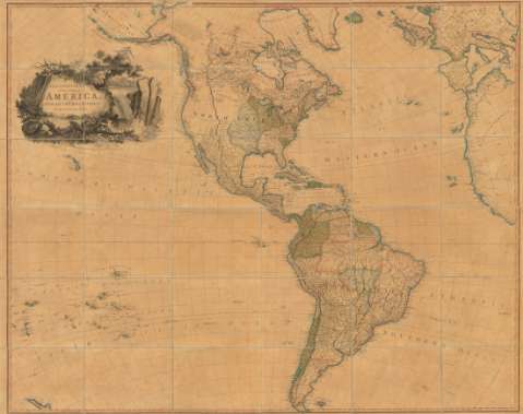
The Continent and Islands of America, With all the...


 Mapas, planos y cartas náuticas
The Continent and Islands of America, With all the divisions to the present time (June 25 1809)
Mapas, planos y cartas náuticas
The Continent and Islands of America, With all the divisions to the present time (June 25 1809)
 Disponible Ejemplares
 Sección: Mapas, planos y cartas náuticas
Título uniforme: Mundo. Mapas generales. 1809 (1809?). 1:6944444-1:13888888
Título: The Continent and Islands of America, With all the divisions to the present time / Engrav'd by B.Baker. Islington.
Área de datos: Escala [ca.1:6944444-1:13888888]
Publicación: London : Published... by Laurie & Whittle, June 25 1809
Descripción física: 1 mapa : col., montado en tela ; 117 x 145 cm, pleg. en 21 x 26 cm
Tipo de contenido: Imagen cartográfica
Tipo de medio: computadora
Tipo de soporte: recurso en línea
Notas: Comprende las tierras situadas entre las islas Fiji y el mar Negro
Escala hallada a partir de 1° de latitud [= 1'6 cm] y [= 0'8 cm]. Coordenadas referidas al meridiano de Londres (O 205°--E 25°/N 75°--S 55°)
Relieve de perfil
Indica las divisiones administrativas de diferentes estados y sus posesiones
Título enmarcado en cartela decorada con motivos paisajísticos
En el verso: "Sold by W. Faden Geographer to His Majesty and to his Royal Highness the Prince of Wales. No. 5 Charing Cross"
Materia / lugar / evento: Mapas generales
Divisiones administrativas
Colonias
1809
Otros autores: Baker, Benjamin, fl. 1780-1824
Robert Laurie and James Whittle
CDU: 4/9
Tipo de publicación:
Mapas
Derechos:
Préstamo:
Disponible
