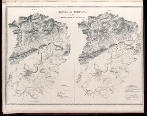
Battle of Pamplona. Plate 1., Shewing the Actions on the...
Sección: Mapas, planos y cartas náuticas
Título uniforme: Pamplona. Batallas. 1840. 1:25.500 (1813)
Título: Battle of Pamplona. Plate 1., Shewing the Actions on the 27th. & 28th. July, 1813 [Material cartográfico] / Engraved by Stockley form the original survey and drawing by Major Sir T.L. Mitchell
Área de datos: Escala [ca. 1:25.500]. 1 English Mile [= 6,3 cm]
Descripción física: 2 mapas en 1 h. ; 84 x 64 cm
Notas: Relieve representado por normales
Vegetación representada en algunas zonas
Leyenda explicativa con el desarrollo de la contienda
Contenido incompleto: [1] 27th.
Contenido parcial: [2] 28th.
Registros relacionados: En: Maps & Plans, showing the principal Movements, Battles & Sieges, in which the British Army was engaged during the War from 1808 to 1814 in the Spanish Peninsula and the South of France. - London : printed by Day & Haghe, [1840]
Materia / lugar / evento: Batallas
Sitios
Operaciones bélicas
Guerras de independencia
1813
Pamplona
Navarra (Comunidad Autónoma)
España
CDU: 460
Tipo de publicación:
![]() Artículos y Capítulos
Artículos y Capítulos


