Movements of the two armies after the repulse of Marshal...


 Mapas, planos y cartas náuticas
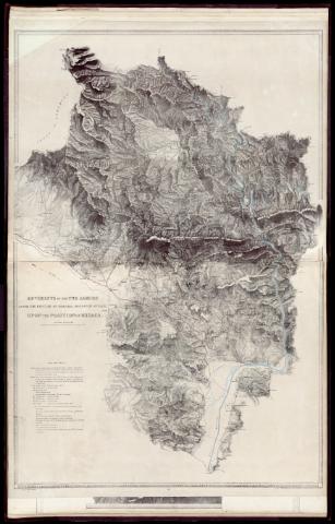
Movements of the two armies after the repulse of Marshal Massena's attack upon the position of Busaco
Mapas, planos y cartas náuticas
Movements of the two armies after the repulse of Marshal Massena's attack upon the position of Busaco
Sección: Mapas, planos y cartas náuticas
Título uniforme: BUSSACO (Portugal). Batallas. 1840. Escala [ca. 1:42 000]. 1 1/2 Inch to 1 Mile (1810)
Título: Movements of the two armies after the repulse of Marshal Massena's attack upon the position of Busaco [Material cartográfico] / from the original survey & drawing by Major Sir T.L. Mitchell ; on zinc by A. R. Grive
Área de datos: Escala [ca. 1:42 000]. 1 1/2 Inch to 1 Mile
Descripción física: 1 mapa ; 84 x 65 cm
Notas: Relieve representado por normales
Vegetación representada en algunas zonas
Leyenda explicativa con el desarrollo de la contienda
Registros relacionados: En: Maps & Plans, showing the principal Movements, Battles & Sieges, in which the British Army was engaged during the War from 1808 to 1814 in the Spanish Peninsula and the South of France. - London : printed by Day & Haghe, [1840]
Materia / lugar / evento: Batallas
Operaciones bélicas
Guerras de independencia
1810
Bussaco (Sierra)
Coimbra
Portugal
Gran Bretaña
CDU: 469
Tipo de publicación:
Artículos y Capítulos
Derechos:
