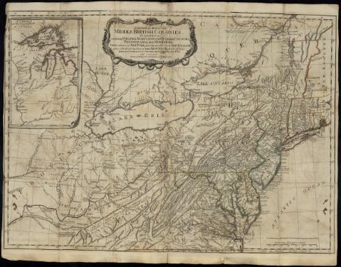
General Map of the Middle British Colonies, in America :...
Sección: Mapas, planos y cartas náuticas
Título uniforme: AMERICA DEL NORTE. Mapas generales. 1:2000000 (1776)
Título: General Map of the Middle British Colonies, in America : containing Virginia, Maryland, the Delaware Countils, Pennsylvania and New Jersey, With the addition of New York, and of the Greatest Part of New England, as also of the Bordering Parts of the Province of Quebec, improved from several Surveys made after the late War / and Corrected from Governor Pownall's late Map 1776
Área de datos: [Ca. 1:2000000], 130 British Statute Miles 69 1/2 to a Degree [= 10,1 cm]
Publicación: London : Printed for R. Sayer & Bennet, Map. Chart & Printseller, N° 53, Fleet Street, as the Act directs., 15 th. Oct. 1776
Descripción física: 1 mapa : col ; 49 x 66 cm, pleg. en 22 x 12 cm
Notas: Proyec. cónica directa equidistante. Coordenadas referidas a los meridianos de Londres (O 89º49´-O 71º00´/N 45º50´- N 36º30´) y Filadelfia (O 14º10´-E 04º30´/N 36º30´). Red geográfica de 1º en 1º
Relieve de perfil
Indica veriles y fondeaderos
En el margen superior: "The seat of War in the Middle Colonies containing Virginia, Maryland, the Delaware, countries & ca."
Señala los límites entre administraciones por colores
Título enmarcado en cartela decorada con motivos vegetales y arquitectónicos
Inserta: "A Sketch of the Upper Parts of Canada" - [Ca. 1:6000000]
En: The American Military Pocket Atlas...[Mapa] 4
Materia / lugar / evento: Mapas generales
Divisiones administrativas
Colonias
1776
América del Norte
Otros autores: Robert Sayer and John Bennett (Firma)
Títulos secundarios: Título: The American Military Pocket Atlas
CDU: 7-11
Tipo de publicación:
![]() Mapas
Mapas


