A Map of the most inhabited part of New England :...


 Mapas, planos y cartas náuticas
A Map of the most inhabited part of New England : containing the Provinces of Massachusets Bay and New Hampshire... (1777)
Mapas, planos y cartas náuticas
A Map of the most inhabited part of New England : containing the Provinces of Massachusets Bay and New Hampshire... (1777)
 Disponible Ejemplares
 Sección: Mapas, planos y cartas náuticas
Título uniforme: Estados Unidos. NE. Mapas generales. 1:451671 (1777)
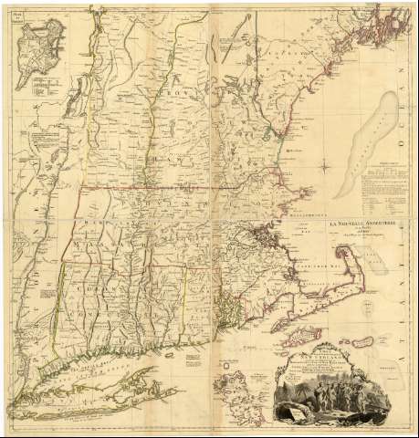
Título: A Map of the most inhabited part of New England : containing the Provinces of Massachusets Bay and New Hampshire with the Colonies of Conecticut and Rhode Island divided into Counties and Townships : The whole composed from Actual Surveys and its Situation adjusted by Astronomical Observations [Mapa]
Área de datos: Escala [ca. 1:451671]
Publicación: Paris : After the Original by M. Le Rouge, Austin Street, 1777
Descripción física: 1 map. en 2 h. : col. ; 102 x 94 cm, en h. de 66 x 95 cm, pleg. en 66 x 48 cm
Notas: En: Atlas geográfico universal. 1798?. T.III maps. 30-31
Esquina superior derecha de la hoja 2 : "La Nouvelle Anglaterre en 4 Feuilles. A Paris ; Chez le Rouge rue des Grands Augustins, 1777"
Escala gráfica de 10 leguas marinas [= 12,3 cm]. Coordenadas referidas a los meridianos de Hierro (O 56°40'--O 51°20'/N 44°30'--N 40°28'). Red geográfica de 30' en 30'. Orientado con rosa de cuatro vientos incluida en círculo y lis
Orografía de perfiles. Veriles, bajos y bancos indicados con líneas de puntos, cruces y punteado
Clave toponímica de símbolos y letras capitales
Nota en la que se relacionan los trabajos que se han tenido como base para levantar esta carta
Mediante colores se indican los límites de las colonias y con líneas discontinuas las divisiones administrativas dentro de ellas
Cartela rococó con escena referente a la llegada de los primeros colonos a Plymouth en 1620 que encuadra título, pie de imprenta y fecha
Inserta: "Plan de Boston".- Escala [ca. 1:20808], 1 milla [= 8,9 cm]. Orientado con lis. Relación de los principales edificios mediante clave alfabética. "A Plan of Boston Harbor from an Accurate Survey".- Escala [ca. 1:168350], 5 millas [= 5,4 cm]. Sondas batimétricas
Materia / lugar / evento: Mapas generales
Planos de población
Cartas náuticas
Colonias
Divisiones administrativas
1777
Boston
Massachusetts
Otros autores: Le Rouge, George-Louis, 1712-ca. 1790
CDU: 912:325.45]:314(084.3):551.46(73-11-2/-5)"1777"
73-11
Tipo de publicación:
Mapas
Derechos:
Préstamo:
Disponible
