General map Showing the Vicinity of the Route proposed by...


 Mapas, planos y cartas náuticas
General map Showing the Vicinity of the Route proposed by Commander T.O. Selfridge U.S. Navy : for an Interoceanic... (1875)
Mapas, planos y cartas náuticas
General map Showing the Vicinity of the Route proposed by Commander T.O. Selfridge U.S. Navy : for an Interoceanic... (1875)
 Disponible Ejemplares
 Sección: Mapas, planos y cartas náuticas
Título uniforme: NAPIPI (Colombia) (Chocó) (Río). Canales. 1:21000 (1875?)
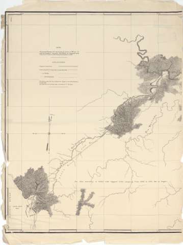
Título: General map Showing the Vicinity of the Route proposed by Commander T.O. Selfridge U.S. Navy : for an Interoceanic shipconal by ray of the Atrato, Napipi and Doguardo Rivers in the Canton of Choco, State of Cauca, U.S. of Colombia : Sheet no. 1 [Mapa] / U.S. Expedition 1875, Lieutencot Fredericj Collins, U.S. Navu Commendind; Lieut. Jos G. Eaton... [et al.]
Área de datos: Escala [ca. 1:21000] (O 77°20'29''--O 77°07'52'' / N 6°40'21''--N 6°32'28'')
Publicación: [s.l. : s.n.], 1875
Descripción física: 1 map. en 2 h. ; 75 x 120 cm en h. de 82 x 62 cm
Notas: Presenta el terreno comprendido entre el río Guía y Napipi, la confluencia de éste con el Doguado hasta la bahái de Chirichire
Escala gráfica de 11000 pies [= 16'1 cm]. Red geográfica de 1' en 1'. orientado con flecha el Norte geográfico y magnético
Orografía por curvas de configuración y puntos acotados
Tabla de los signos empleados para indicar el trazado del canal proyectado y el de un recorrido alternativo considerado más ventajoso, así como las rutas por las que se llevaron a cabó los reconocimientos
Nota en la que se mencionan las fechas en que fueron tomadas los datos sobre las corrientes de los ríos, 1871 y 1873 y los de carácter topográfico, 1875
Se relacionan con el mapa con sig. SGE J-7-3--159, que muestra la primera parte del proyecto, la unión del río Atrato con el Napipi
Otros autores: Eaton, Jos. G
Collins, Frederick
CDU: (861.56:282.28 Napipi)
Tipo de publicación:
Mapas
Derechos:
Préstamo:
Disponible
