Map of the Region between Gettisburg, PA. and Appomattox...


 Mapas, planos y cartas náuticas
Map of the Region between Gettisburg, PA. and Appomattox Court House, VA. exhibiting the connection between the... (1869)
Mapas, planos y cartas náuticas
Map of the Region between Gettisburg, PA. and Appomattox Court House, VA. exhibiting the connection between the... (1869)
 Disponible Ejemplares
 Sección: Mapas, planos y cartas náuticas
Título uniforme: Estados Unidos. E. Mapas topográficos. 1:265000 (1869)
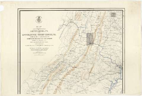
Título: Map of the Region between Gettisburg, PA. and Appomattox Court House, VA. exhibiting the connection between the Campaigh and battle-field maps / prepared by Authority of the Hon. Secretary of War, under the direction of Brig. & But. Maj. Genl. A.A. Humphreys, Chief of Eng'rs., U.S.A. by But. Brig. Gen'l. N. Michler, Major of Eng'rs. from Surveys by But. Brig. Gen'l N. Michler, Maj. of Engs. and others, and from Data in the Engineers Department ; compiled and drawn by Major John E. Weyss, C. Thompson and J. De la Camp
Área de datos: Escala [ca. 1:265000 ; proy. cónica] (O 79°15'--O 77°00'/N 40°00'--N 37°00')
Publicación: [Washington] : War Depàrtment, Office of the Chief of Engineers, 1869
Descripción física: 1 mapa en 2 hoja : col. ; 113 x 69 cm, hoja de 61 x 91 cm
Tipo de contenido: Imagen cartográfica
Tipo de medio: computadora
Tipo de soporte: recurso en línea
Notas: Comprende parte de los estados de Pennsylvania, Maryland, Virginia y Virginia Occidental
Escala gráfica de 10 millas [= 6'1 cm]. Red geográfica de 30' en 30'
Relieve representado por sombreado
Señala con recuadros de color gris los mapas de esa zona que han sido publicados y en los que se muestran las posiciones de ambos ejércitos durante la Guerra de Secesión (mapas con sig. J-2-3-151 a 166)
Sello impreso de la entidad editora, con la fecha de publicación
Materia / lugar / evento: Mapas topográficos
Otros autores: Michler, N
De la Camp, J
Weyss, J. E
Thompson, G
Estados Unidos. War Department
Estados Unidos. Army. Office of the Chief of Engineers
CDU: 912:(73-11)"1869"
73-11
Tipo de publicación:
Mapas
Derechos:
Préstamo:
Disponible
