A New Map of Jamaica : In which the Several Towns, Forts,...


 Mapas, planos y cartas náuticas
A New Map of Jamaica : In which the Several Towns, Forts, and Settlements... Harbours and Anchoring Places...... (1750?)
Mapas, planos y cartas náuticas
A New Map of Jamaica : In which the Several Towns, Forts, and Settlements... Harbours and Anchoring Places...... (1750?)
 Disponible Ejemplares
 Sección: Mapas, planos y cartas náuticas
Título uniforme: JAMAICA. Mapas generales (1730-1749). 1:232118
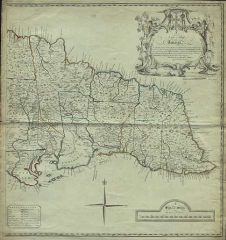
Título: A New Map of Jamaica : In which the Several Towns, Forts, and Settlements... Harbours and Anchoring Places... Parishes... / The greatest part Drawn or Corrected from actual Surveys Made by Mr. Sheffield and others, from the year 1730 to the year 1749 ; Inscrib'd to the Gentlemen of the Island By their humble Servant Patk Browne ; I Bayly Sculp
Área de datos: Scale [ca. 1:232.118]. 30 miles 69 to a degree [= 20,8 cm]
Publicación: London : Carington Bowles, St. Pauls Charch Yard, [1750?]
Descripción física: 1 mapa en 2 h. : grab., col. ; 70 x 65,8 cm
Tipo de contenido: Imagen cartográfica
Tipo de medio: computadora
Tipo de soporte: recurso en línea
Notas: Márgenes graduados. Orientado con rosa de 4 vientos y lis
Relieve representado por montes de perfil. Costas sombreadas con un fino rayado. Divisiones administrativas diferenciadas por líneas de color. Hidrografía
Indica veriles, bajos, fondeaderos y sondas batimétricas
Tabla de símbolos convencionales para indicar fortificaciones, núcleos de población de distinta categoría, etc.
Título enmarcado en cartela barroca con pareja de nativos y la leyenda: "Indus uterque serviet uni"
Figura sólo una hoja
Materia / lugar / evento: Mapas generales
Divisiones administrativas
Poblaciones indígenas
Jamaica
Otros autores: Sheffield
Bayly, John, fl. 1755-1794
Bowles, Carrington, 1724-1793
Browne, Patrick
CDU: 729.2
Tipo de publicación:
Mapas
Derechos:
Préstamo:
Disponible
