A New general chart of the Atlantic or Western Ocean and...


 Mapas, planos y cartas náuticas
A New general chart of the Atlantic or Western Ocean and adjacent seas : including the coasts of Europe and Africa... (1786)
Mapas, planos y cartas náuticas
A New general chart of the Atlantic or Western Ocean and adjacent seas : including the coasts of Europe and Africa... (1786)
 Disponible Ejemplares
 Sección: Mapas, planos y cartas náuticas
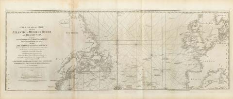
Título uniforme: Océano Atlántico Norte. Cartas náuticas. 1777 (1769). 1:6.900.000
Título: A New general chart of the Atlantic or Western Ocean and adjacent seas : including the coasts of Europe and Africa from 60 Degrees North Latitude to the Equator and also the opposite coast of America / Drawn and Regulated by th most accurate Astronomic observations, and the Journals of the most experienced Naveigators in wich also ase particulary distinguished the determinations of the longitude as given by the Marine Clocks of Mr Ferdinand Berthoud in the Voyage performed by order of the Government of France, in 1768 and 1769 in the Ship Isis to the Azores, Madera, the Canaries, Cape-Verde Islands ; by Mr De Fleurieu an Officer in the French Navy and Member of the Royal Marine Academy ; Printed for Robert Sayer and Jhon Bennett
Área de datos: [Ca. 1:6900000] (O 103°39'46''-E 14°39'46''/N 61°10'00''-N 36°40'00")
Publicación: London : Robert Sayer and Jhon Bennett, 1786
Descripción física: 1 carta náutica ; 49 x 140 cm, pleg. en 62 x 45 cm
Notas: Escala gráfica paralela al eje de latitud, expresada en leguas marítimas de 20 al grado. Graduada. Longitud referida a los meridianos de Londres y Hierro. Orientada con dos lises, con sus correspondientes rosas
Indica sondas batimétricas
Describe detalladamente la toponimia costera
Indica los derroteros a seguir
En: The East India Pilot, or Oriental Navigator. ParteI, mapa 13
Materia / lugar / evento: Cartas náuticas
Expediciones geográficas
Derroteros
Toponimia
1769
Europa
América del Norte
África
Océano Atlántico Norte
Otros autores: Fleurieu, Charles Pierre Claret, comte de, 1738-1810
Berthoud, Ferdinand, 1727-1807
Bennett, John
Sayer, Robert, 1725-1794
CDU: (7-11)
Tipo de publicación:
Mapas
Derechos:
Préstamo:
Disponible
