A General map of the East Indies : Exhibiting in the...


 Mapas, planos y cartas náuticas
A General map of the East Indies : Exhibiting in the Peninsula on this side of the Ganges or Indostan the several... (1783)
Mapas, planos y cartas náuticas
A General map of the East Indies : Exhibiting in the Peninsula on this side of the Ganges or Indostan the several... (1783)
 Disponible Ejemplares
 Sección: Mapas, planos y cartas náuticas
Título uniforme: Asia. Colonias (1783). 1:7100000
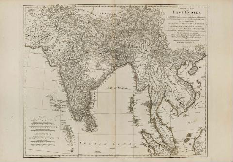
Título: A General map of the East Indies : Exhibiting in the Peninsula on this side of the Ganges or Indostan the several partitions of the Mogul's Empire and the dominions of the english East India company in the Provinces of Beugal, Bahar and Oriwa, as well as upon the coast of Malabar and Coromandel with the French and Dutch Possessions according to the Peace of 1783 and in the Peninsula Beyond the Ganges, the Kingdoms of Assam, Cashar, Ana, Aracan, Mien, Pegu, Siam. Lao and Cambodia, with Malaya, Conchinchina and Tonkin / By Tho Jefferys, Geographer to the King; London Printed for Rost Sayer, and John Bennett No. 53 in Fleet street as the Act directis, Dec'1st 1783
Área de datos: [Ca. 1:7100000] (E 63°00'46''-E 112°00'46''/N 34°00'00''-S 1°30'00'')
Publicación: London : Robert Sayer and John Bennett, 1783
Descripción física: 1 mapa ; 57 x 71 cm
Notas: En: The East-Indian Pilot, or Oriental Navigator. Part. I. N. 1
Presenta ocho escalas gráficas, expresadas en diferentes medidas orientales: de India, Persia, China, Malasbar e inglesas, una en concreto de 400 millas legales de 69 1/2 al grado [= 9,1 cm]. Documento graduado, longitud tomada respecto del meridiano de Hierro
Describe detalladamente la toponimia
El teritorio asiático aparece dividido políticamente
Litoral sombreado
Otros autores: Jefferys, Thomas, ca. 1710-1771
Bennett, John
Sayer, Robert, 1725-1794
CDU: 912:911.2]:325.45(5-4)"17"
5-4
Tipo de publicación:
Mapas
Derechos:
Préstamo:
Disponible
