A New Hidrographical survey of the British Channel : with...


 Mapas, planos y cartas náuticas
A New Hidrographical survey of the British Channel : with part of the Atlantic Ocean as for as Cape Clear (1782)
Mapas, planos y cartas náuticas
A New Hidrographical survey of the British Channel : with part of the Atlantic Ocean as for as Cape Clear (1782)
 Disponible Ejemplares
 Sección: Mapas, planos y cartas náuticas
Título uniforme: LA MANCHA (Canal). Cartas náuticas (1782). 1:657000
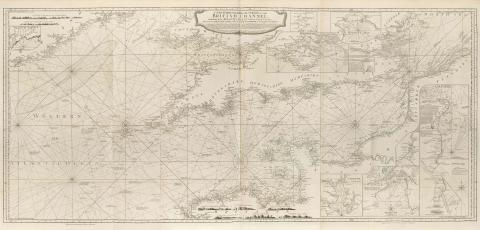
Título: A New Hidrographical survey of the British Channel : with part of the Atlantic Ocean as for as Cape Clear [Mapa] / Improved from the large Chart of the late Thomas Jeffery's Geographer to the King ; London Printed for Robt. Sayer and Jn Bennett No. 53 Fleet Street the Act directs 1 march 1782
Área de datos: Escala [ca. 1:657000]
Publicación: London : Robert Sayer and John Bennett, 1782
Descripción física: 1 map. ; 69 x 153 cm, pleg. 59 x 42 cm
Notas: En : "The East-India Pilot, or Oriental Navigator" Part. I, map. no.3
Consta escala gráfica de leguas marinas, paralela al eje de latitud
Documento graduado, longitud respecto del meridiano de Londres
Orientado con tres líses, con sus correspondientes rosas
Contiene análisis batimétrico de la zona marítima representada
Indica la altura y dirección de las mareas mediante dígitos romanos
Inserta los siguientes planos : "Baltimore Harbour", "Mevagizey Bay", "Mounts Bay", "Isle ofWight", "The downs", "Fowey or Foy", "Portland", "Plymouth", "Falmouth"
Materia / lugar / evento: Cartas náuticas
Estrechos
Otros autores: Jefferys, Thomas, ca. 1710-1771
Bennett, John
Sayer, Robert, 1725-1794
CDU: 912:551.46]:551.42(26.06)"17"
410:26.06 La Mancha
410:26.06 La Mancha
Tipo de publicación:
Mapas
Derechos:
Préstamo:
Disponible
