A new chart of the southern coast of Africa : From the...


 Mapas, planos y cartas náuticas
A new chart of the southern coast of Africa : From the cape of Good Hope to Dalagoa Bay With the Bank of Cape Agulhas (1781)
Mapas, planos y cartas náuticas
A new chart of the southern coast of Africa : From the cape of Good Hope to Dalagoa Bay With the Bank of Cape Agulhas (1781)
 Disponible Ejemplares
 Sección: Mapas, planos y cartas náuticas
Título uniforme: SUDAFRICA (Costa meridional). Cartas náuticas (1781). 1:2268000
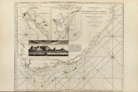
Título: A new chart of the southern coast of Africa : From the cape of Good Hope to Dalagoa Bay With the Bank of Cape Agulhas [Mapa] / Its Soundings, currents inserted chiesty from the papers of Mr. Gerar de Ruyter, Captain of the Port at the Cape of Good Hope ; Printed for Robert Sayer and John Bennett, 1781
Área de datos: Escala [ca. 1:2268000]
Publicación: London : Robert Sayer and John Bennett, 1781
Descripción física: 1 map. ; 59 x 72 cm
Notas: En : "The East India Pilot or oriental Navigator", part. I, map. n° 27
Coordenadas referidas al meridiano de Londres
Consta escala gráfica paralela al eje de latitud, expresada en leguas marinas de 20 al grado
Orientado con rosa y lis
Indica sondas batimétricas en la zona cercana a la costa
Señala la dirección de las corrientes mediante flechas
Aparece detallada la derrota a seguir para bordear el cabo de Buena Esperanza
Inserta una perspectiva de costa : "A view of the cape of Good Hope" ; "A plan of Saldaha bay". Escala [ca. 1:150000], "A plan of Lagoa bay". Escala [ca. 1:631000]
Materia / lugar / evento: Cartas náuticas
Bahías
Perspectivas de costas
Mozambique
Otros autores: Bennett, John
Sayer, Robert, 1725-1794
Ruyter, Gerard
CDU: 912:551.468]:742]:551.468(680)"17"
680
Tipo de publicación:
Mapas
Derechos:
Préstamo:
Disponible
