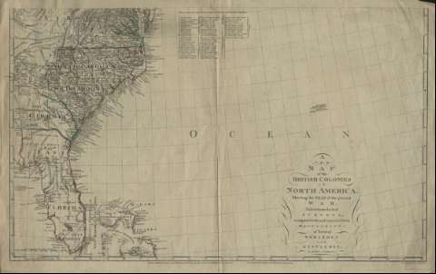
A new map of the British Colonies in North America :...


 Mapas, planos y cartas náuticas
A new map of the British Colonies in North America : Shewing the seat of the present war, takefrom the best surveys,... (1777)
Mapas, planos y cartas náuticas
A new map of the British Colonies in North America : Shewing the seat of the present war, takefrom the best surveys,... (1777)
 Disponible Ejemplares
 Sección: Mapas, planos y cartas náuticas
Título uniforme: Estados Unidos. E. Colonias (1777). 1:3537033
Título: A new map of the British Colonies in North America : Shewing the seat of the present war, takefrom the best surveys, compared with and improved from manuscripts pf several noblemen and gentlemen / by John Andrews
Área de datos: Escala [ca. 1:3537033]
Publicación: London : John Andrews ; Andrew Dury, 1777
Descripción física: 1 mapa en 2 h. : col. ; h. de 55 x 82 cm
Tipo de contenido: Imagen cartográfica
Tipo de medio: computadora
Tipo de soporte: recurso en línea
Notas: Escala gráfica de 200 millas inglesas [= 9,1 cm]
Constan coordenadas del meridiano de Londres
Inserta relación de topónimos
Materia / lugar / evento: Colonias
América del Norte
Otros autores: Dury, Andrew
Andrews, John, 1736-1809
CDU: 912:325.45(73)
73
Tipo de publicación:
Mapas
Derechos:
Préstamo:
Disponible
