A New and General Map of the Middle Dominions Belonging...


 Mapas, planos y cartas náuticas
A New and General Map of the Middle Dominions Belonging to the United States of América : viz Virginia, Maryland,... (1788)
Mapas, planos y cartas náuticas
A New and General Map of the Middle Dominions Belonging to the United States of América : viz Virginia, Maryland,... (1788)
 Disponible Ejemplares
 Sección: Mapas, planos y cartas náuticas
Título uniforme: Estados Unidos. Mapas generales. 1788. 1:2.000.000
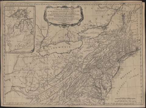
Título: A New and General Map of the Middle Dominions Belonging to the United States of América : viz Virginia, Maryland, the Delaware-Counties, Pennsylvania, New Jersey, etc. with the Addition of New York, and of the Greatest Part of New England, etc. as also of the Bordering of the British Possessions in Canadá
Área de datos: Escala [ca. 1:2.000.000]. 130 british statute miles 69 1/2 to a degree [= 10,1 cm] ; proyec. cónica ( (O 85º25'-O 71º50'/N 46º45'-N 36º25')
Publicación: London : Robert Sayer, 1788
Descripción física: 1 mapa : grab. ; 49 x 67 cm
Tipo de contenido: Imagen cartográfica
Tipo de medio: computadora
Tipo de soporte: recurso en línea
Notas: Escala también expresada en 40 leguas de 20 al grado
Meridiano de origen: Londres. Red geográfica de 1º en 1º
Relieve por montes de perfil. Figura red hdrográfica
Abundante toponimia
Divisiones administrativas diferenciadas por líneas punteadas
Costas sombreadas
Título enmarcado en cartela orlada
Inserta: "A Sketch of the Upper Parts to shew the Rematinder of the Lakes"
Materia / lugar / evento: Mapas generales
Relaciones exteriores
Fronteras
Estados Unidos
Otros autores: Sayer, Robert, 1725-1794
CDU: (73-11)
Tipo de publicación:
Mapas
Derechos:
Préstamo:
Disponible
