A New map of the Hindoostan from the latest authorities :...


 Mapas, planos y cartas náuticas
A New map of the Hindoostan from the latest authorities : chiefly from the Actual Surveys made by Major James... (1789)
- Rennell, James, 1742-1830
Mapas, planos y cartas náuticas
A New map of the Hindoostan from the latest authorities : chiefly from the Actual Surveys made by Major James... (1789)
- Rennell, James, 1742-1830
 Disponible Ejemplares
 Sección: Mapas, planos y cartas náuticas
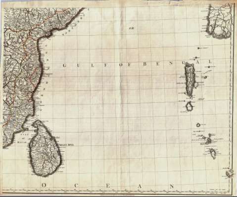
Título: A New map of the Hindoostan from the latest authorities : chiefly from the Actual Surveys made by Major James Rennell, Surveyor General to the Hble. East India Company, of the Bengal provinces, and of the countries lying between them and Dehly : the whole exhibiting all the military roads and passes as well as the most accurate Division of the British Possessions in the East Indies
Autor: Rennell, James, 1742-1830
[A New map of the Hindoostan from the latest authorities] Todas las ediciones
Características de edición: 1789. 1:2575000. Inglés
Área de datos: Escala [ca. 1:2.575.000]
Publicación: London : Publish'd by Robert Sayer Map & Printseller, n° 53, Fleet Street, as the Act directs, 1789
Descripción física: 1 mapa en 4h. : col. ; 117 x 146 ccm, en h. de 62 x 75 cm o menor
Tipo de contenido: Imagen cartográfica
Tipo de medio: computadora
Tipo de soporte: recurso en línea
Notas: Comprende la península del Indostán, Birmania y el sur del Tibet
Escalas gráficas de 200 millas estatutarias [= 12'5 cm], 80 leguas de 30 en grado, 60 leguas náuticas de 20 en grado, 100 "Jeribi" y 120 "Rifmi". Coordenadas referidas a los meridianos de Ferro (E 75°20'--E 114°40'/N 30°30'--N 4°20') y París (E 57°50'--E 97°10'). Red geográfica de 1° en 1°
Orografía de perfil. Indica bajos y veriles
Relación de las distintas provincias en que están divididas las posesiones británicas en la península, indicadas por clave cromática
Título, autor, impresor y escalas enmarcados en dos cartelas
Reproducción digital
Género / forma: Documentos archivísticos
Mapas generales
Otros autores: Sayer, Robert, 1725-1794
España. Dirección de Hidrografía, productor. Expediciones a Indias
Archivo del Museo Naval. Documentos gráficos, Mapas
Tipo de publicación:
Mapas
Derechos:
Préstamo:
Disponible
