The Kingdoms of Bengala, Bahár, and parts of Orissa :...


 Mapas, planos y cartas náuticas
The Kingdoms of Bengala, Bahár, and parts of Orissa : which are now under the Dominion of the Honble. Society of... (May 20th. 1773)
- Bolts, William
Mapas, planos y cartas náuticas
The Kingdoms of Bengala, Bahár, and parts of Orissa : which are now under the Dominion of the Honble. Society of... (May 20th. 1773)
- Bolts, William
 Disponible Ejemplares
 Sección: Mapas, planos y cartas náuticas
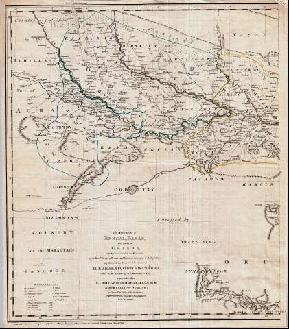
Título: The Kingdoms of Bengala, Bahár, and parts of Orissa : which are now under the Dominion of the Honble. Society of English Merchants trading to the East Indies : together with the Conquered Provincies of Iblhabâd, Owd & Banáras, which by the Servants of the Said Society, in 1765, Were conferred on The Mogul Emperor, Shah Allum and the Nabôb Sujah-Al-Dowlah : as survey'd by Order of the Company / William Bolts ; engraved by Faden and Jefferys Geographer to his Majesty
Autor: Bolts, William
[The Kingdoms of Bengala, Bahár, and parts of Orissa] Todas las ediciones
Características de edición: 1773. 1:1464000. Inglés
Área de datos: Escala [ca. 1:1.464.000]
Publicación: London : Published according to Act of Parliament, by Jefferys & Faden, The Corner of St. Martins Lane Charing-Cross, May 20th. 1773
Descripción física: 1 mapa en 2 h. : col. ; 104 x 59 cm en h. de 62 x 54 cm
Tipo de contenido: Imagen cartográfica
Tipo de medio: computadora
Tipo de soporte: recurso en línea
Notas: Comprende la parte noreste de la India y Bangladesh
Dedicatoria : "To the Right Honble. Frederick Lord North, First Lord of the Treasury ; The Right Honble. Thomas Harley, Major General John Burgoyne... and the rest of the Members of the Secret & Select committes of the Honble. The House of commons on India-affairs ; whose Names, for their disinterested researches, the Natives & the Oppressed in India, may eventually have reason, grateffully to venerate, so long as the British maintain their Empire in Asia"
Divisiones provinciales diferenciadas por color
Escala gráfica de 70 millas estatutarias [= 7'7 cm]. Coordenadas referidas al meridiano de Londres (E 78°50'--E 93°50'/N 28°10'--N 20°30') y al de Calcuta (O 10°10'--E 4°50'). Red geográfica de 1° en 1°. Orientado con lis
Orografía de perfil. Indica sondas batimétricas, veriles y fondeaderos
Tabla de signos convencionales para señalar la categoría de los núcleos de población
Reproducción digital
Materia / lugar / evento: Divisiones administrativas
Género / forma: Documentos archivísticos
Mapas generales
Otros autores: España. Dirección de Hidrografía, productor. Expediciones a Indias
Archivo del Museo Naval. Documentos gráficos, Mapas
Jefferys and Faden (Londres)
Tipo de publicación:
Mapas
Derechos:
Préstamo:
Disponible
