This Chart of Felicia and Plan of the Island Balambangan...


 Mapas, planos y cartas náuticas
This Chart of Felicia and Plan of the Island Balambangan : is humbly presented by his Majesty's faithful subject... (Novr. 30 1770)
- Henry, B
Mapas, planos y cartas náuticas
This Chart of Felicia and Plan of the Island Balambangan : is humbly presented by his Majesty's faithful subject... (Novr. 30 1770)
- Henry, B
 Disponible Ejemplares
 Sección: Mapas, planos y cartas náuticas
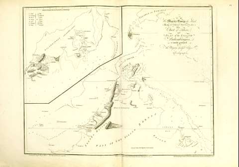
Título: This Chart of Felicia and Plan of the Island Balambangan : is humbly presented by his Majesty's faithful subject Dalrymple / Graduated & Engrav'd by B. Henry ; The Hills Etch'd by D. Lerpeniere ; The Writing Engraved by W. Whitchurch, Bartholomew Lane, Royal Exchange, London
Área de datos: Escala [ca. 1:740741]
Publicación: [London] : Published... by Alexander Dalrymple, Novr. 30 1770
Descripción física: 1 carta náutica ; 47 x 62 cm
Tipo de contenido: Imagen cartográfica
Tipo de medio: computadora
Tipo de soporte: recurso en línea
Notas: Comprende el norte del estado de Sabah, el estrecho de Balabac y la isla filipina del mismo nombre y el sur de la de Palawan, indicando las sondas, bajos, veriles y toponimia costera
Relieve representado por medio de normales
La dedicatoria precede al título : "To his Majesty George the Third, King of Great Britain, & C.". Todo ello grabado en diferentes tipografías y adornaodo con filigranas, en el ángulo superior derecho
Escala hallada según la equivalencia en cm de un arco de meridiano de 15 cm
Graduado sólo en latitud : (N 8°30'--N 5°30')
Lugar de publicación tomado del "Tooley's Dictionary of Mapmakers", p. 144
Copia digital. Madrid : Ministerio de Cultura, 2010
Inserta : Mapa de la isla de Balambangan. Escala [ca. 1:93058], expresada en millas náuticas de 60 al grado. Presenta el mismo contenido que el mapa principal
Registros relacionados: En: Le Neptune Oriental : dédié au Roi. - A París, rue S. Severin... ; Et A Brest : Chez Demonville, Imprimeur-Libraire de l'Academie Francoise... : Chez Malassis, Imprimeur-Libraire de la Marine, 1775. - 55
Otros autores: Dalrymple, Alexander
Lerpinière, Daniel, 1745-1785
Whitchurch, William
Títulos secundarios: Sabah (Malasia). Cartas náuticas. 1770. 1:740741
CDU: (592.6+594.1+595.41/.43)"1770"
Tipo de publicación:
Mapas
Préstamo:
 Disponible sólo para consulta en sala
