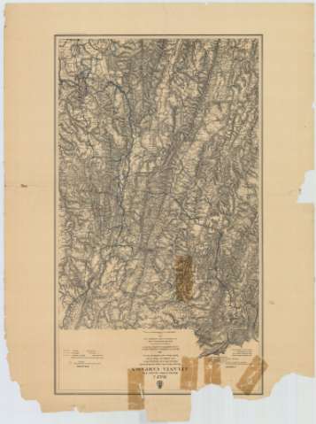
Map 1 illustrating the Military Operations of Atlanta...


 Mapas, planos y cartas náuticas
Map 1 illustrating the Military Operations of Atlanta Campaign : This map embraces the region extending from the... (1875)
Mapas, planos y cartas náuticas
Map 1 illustrating the Military Operations of Atlanta Campaign : This map embraces the region extending from the... (1875)
 Disponible Ejemplares
 Sección: Mapas, planos y cartas náuticas
Título uniforme: ALABAMA (Estados Unidos). Operaciones bélicas. 1875 (1864). 1:86215
Título: Map 1 illustrating the Military Operations of Atlanta Campaign : This map embraces the region extending from the Tennesse River to the Oostanaula River and exhibits the Works of the United States and Confederate Forces 1864 Maj. Genl. W. T. Sherman, commanding U.S. Forces Genl. J.E. Johnston, comanding Conf-Forces / Compiled by authority of the H. The Secretary of war in the Office of the Office of the Chief of Engineers, U.S.A., 1875
Área de datos: [Ca. 1:86215], 3 statute miles [= 5,6 cm]
Publicación: [Washington] : Office of the Chief of Engineers, 1875
Descripción física: 1 mapa : col., montado sobre tela ; 88 x 51 cm
Tipo de contenido: Imagen cartográfica
Tipo de medio: computadora
Tipo de soporte: recurso en línea
Notas: Comprende la parte septentrional del estado norteamericano de Alabama y la noroccidental del de Georgia
Relieve representado por normales
Tabla de signos convencionales para señalar las operaciones efectuadas por los ejércitos federal y confederado en esta zona
Nota que señala todos aquellos trabajos tenidos en cuenta para la elaboración del presente mapa
Materia / lugar / evento: Operaciones bélicas
Mapas generales
1864
Georgia (Estados Unidos)
Estados Unidos
Otros autores: Estados Unidos. Army. Office of the Chief of Engineers
CDU: 761-17
758-16
Tipo de publicación:
Mapas
Derechos:
Préstamo:
Disponible
