North End of Green Bay, the Islands and the Entrance and...


 Mapas, planos y cartas náuticas
North End of Green Bay, the Islands and the Entrance and the N.W.Shore of Lake Michigan (1864?)
Mapas, planos y cartas náuticas
North End of Green Bay, the Islands and the Entrance and the N.W.Shore of Lake Michigan (1864?)
 Disponible Ejemplares
 Sección: Mapas, planos y cartas náuticas
Título uniforme: GREEN BAY (Estados Unidos) (Bahía). Cartas náuticas. 1864-1870? (1863-1864). 1:120000
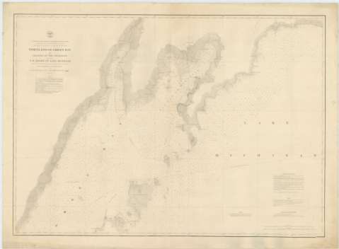
Título: North End of Green Bay, the Islands and the Entrance and the N.W.Shore of Lake Michigan / Proyected from Trigonometrical surveys, executed under the orders of Col. J.D. Graham, U.S. Engrs. in 1863 and Col. W.F. Raynolds. A.D.C. and Major of Engrs., in 1864
Área de datos: Escala 1:120000 (O 87°30'-- O 86°01'/N 45°59'-- N 45°14')
Publicación: [Washington] : Bureau of Engineers of the War Department, 1864?
Descripción física: 1 carta náutica ; 69 x 97 cm
Tipo de contenido: Imagen cartográfica
Tipo de medio: computadora
Tipo de soporte: recurso en línea
Serie: (Survey of the Northern and North Western Lakes)
Notas: Escala también dada en formas gráficas de 10 millas legales [inglesas] y 20000 yardas. Orientado en nudo de treinta y dos rumbos, en el que se señala además la variación magnética observada
Indica sondas batimétricas y veriles, así como las distintas líneas de derrota a seguir para arribar a la bahía
Clave hidrográfica para determinar la calidad del fondo
En nota, se señalan todos aquellos trabajos tenidos en cuenta para la elaboración del presente documento
Materia / lugar / evento: Cartas náuticas
Batimetría
Bahías
Lagos
1864
Míchigan
Estados Unidos
Otros autores: Graham, James Duncan
Raynolds, W. F
Estados Unidos. War Department. Engineer Bureau
CDU: 775-18
Tipo de publicación:
Mapas
Derechos:
Préstamo:
Disponible
