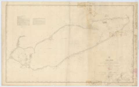
Lake Erie


 Disponible Ejemplares
 Sección: Mapas, planos y cartas náuticas
Título uniforme: ERIE (Estados Unidos) (Lago). Cartas náuticas. 1853 (1849). 1:400000
Título: Lake Erie / Compiled from Surveys made under the direction of the Bureau of Topographical Engineers. War Department.. 1849 ; Reduction for Engraving by John Lambert, Draughtsman, under the Direction of Capt. T.J. Lee, corps Topl. Engrs.
Área de datos: Escala 1:400000 (O 83°10'- O 78°50'/N 41°10'- N 41°00')
Publicación: Washington : War Department. Bureau of Topographical Engineers, 1853
Descripción física: 1 carta náutica ; 60 x 99 cm
Tipo de contenido: Imagen cartográfica
Tipo de medio: computadora
Tipo de soporte: recurso en línea
Notas: Escala también dada en forma gráfica de 60000 yardas y 40 millas legales. Coordenadas también referidas al meridiano de Washington (O 6°10'--O 1°50'). Orientado con nudo de treinta y dos rumbos. Mención de la variación magnética en los faros de la zona
Indica sondas batimétricas y veriles, así como la línea de derrota a seguir para recorrer el lago
Clave hidrográfico para determinar la calida del fondo
En nota se informa de las temperaturas del agua y del aire en varios puntos del lago, así como de las características de la navegabilidad en el mismo
Materia / lugar / evento: Cartas náuticas
Batimetría
Lagos
1849
1853
Erie (Canadá) (Lago)
Otros autores: Lee, T.J
Lambert, John
Estados Unidos. War Department. Engineer Bureau
CDU: 771-77
747-15
748-17
713-13
Tipo de publicación:
 Mapas
Mapas
Derechos:
Préstamo:
Disponible
