Index map exhibiting the position of the several sheets...


 Mapas, planos y cartas náuticas
Index map exhibiting the position of the several sheets of the topographical atlas of the Territory of the United... (1873)
Mapas, planos y cartas náuticas
Index map exhibiting the position of the several sheets of the topographical atlas of the Territory of the United... (1873)
 Disponible Ejemplares
 Sección: Mapas, planos y cartas náuticas
Título uniforme: Estados Unidos. Mapas índice (1873). 1:6000000
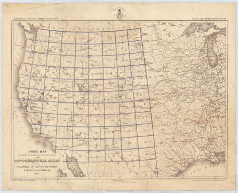
Título: Index map exhibiting the position of the several sheets of the topographical atlas of the Territory of the United States West of the 100th. meridian 1873 / Louis Nell del. 1st. Lieut. Geo. M. Wheeler, Corps of Engineers in charge
Área de datos: Escala 1:6000000 (O 126°--O 91°/N 49°--N 29°)
Publicación: [Washington] : War Department. Corps of engineers U.S. Army, 1873
Descripción física: 1 mapa ; 41 x 57 cm
Tipo de contenido: Imagen cartográfica
Tipo de medio: computadora
Tipo de soporte: recurso en línea
Notas: Comprende la parte occidental de los Estados Unidos, entre los estados de Washington, California, Wisconsin y Luisiana
Escala también dada en forma gráfica de 200 millas [= 5'5 cm]
En el ángulo inferior izquierdo: "Seasons of 1869, 1871, 1872 & 1873"
Figura el sello del Departamento de Guerra, Cuerpo de Ingenieros de los Estados Unidos
Materia / lugar / evento: Mapas índices
1873
CDU: 73-15
Tipo de publicación:
Mapas
Derechos:
Préstamo:
Disponible
