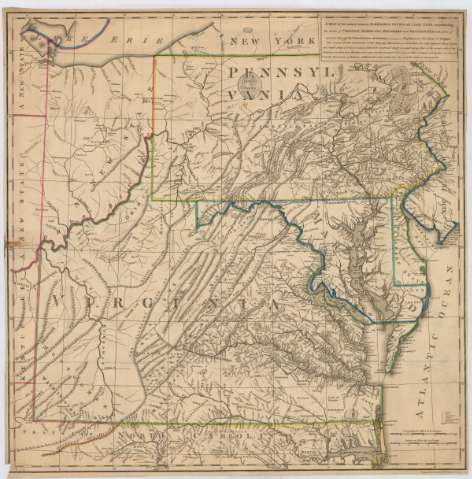
A map of the country between Albemarle Sound and Lake...


 Mapas, planos y cartas náuticas
A map of the country between Albemarle Sound and Lake Erie : comprehending the whole of Virgina, Maryland, Delaware... (1782?)
Mapas, planos y cartas náuticas
A map of the country between Albemarle Sound and Lake Erie : comprehending the whole of Virgina, Maryland, Delaware... (1782?)
 Disponible Ejemplares
 Sección: Mapas, planos y cartas náuticas
Título uniforme: ESTADOS UNIDOS. SE. Mapas generales (1782?). 1:1291988
Título: A map of the country between Albemarle Sound and Lake Erie : comprehending the whole of Virgina, Maryland, Delaware and Pennsylvania, which parts of several other of the United States of America / engraved by S. J. Neele no. 352 strand London
Área de datos: Escala [ca. 1:1291988], 60 geographic miles [= 8,6 cm]
Publicación: [London : [Nombre de editor no identificado], 1782?]
Descripción física: 1 mapa : col. ; 60 x 59 cm
Tipo de contenido: Imagen cartográfica
Tipo de medio: computadora
Tipo de soporte: recurso en línea
Notas: Comprende los estados norteamericanos de Pennsylvania, Delaware, Maryland, Virginia, la parte nororiental del de Virginia del Oeste, y el distrito de Columbia
Escala gráfica también expresada en 70 millas americanas de 69 1/2 al grado [= 8,6 cm]
Relieve de perfil
Fecha de publicación deducida de otros documentos realizados por el grabador
Nota relativa a todos aquellos trabajos tenidos en cuenta para la elaboración del presente documento
Materia / lugar / evento: Mapas generales
Divisiones administrativas
Siglo XVIII
Pensilvania
Estados Unidos
Otros autores: Neele, Samuel John, 1758-1824
CDU: 75
Tipo de publicación:
Mapas
Derechos:
Préstamo:
Disponible
