North East End of Lake Michigan including Grand and...


 Mapas, planos y cartas náuticas
North East End of Lake Michigan including Grand and Little Traverse Bays and the Fox and Manitou Islands (1863)
Mapas, planos y cartas náuticas
North East End of Lake Michigan including Grand and Little Traverse Bays and the Fox and Manitou Islands (1863)
 Disponible Ejemplares
 Sección: Mapas, planos y cartas náuticas
Título uniforme: MICHIGAN (Estados Unidos) (Lago). NE. Cartas náuticas. 1863. 1:120000 (1861-1863)
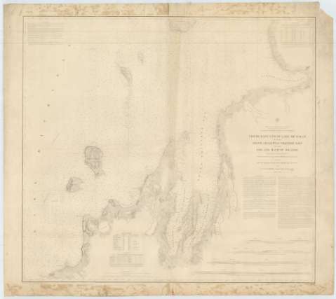
Título: North East End of Lake Michigan including Grand and Little Traverse Bays and the Fox and Manitou Islands / Projected from Trigonometrical Survey under the orders of Capt. Geo. G. Meade Topl. Engrs. in 1861 and drawn under the direction of Capt. Geo. G. Meade Topl. Engrs. in 1861 and H.J.D. Graham Corps of Engrs. in 1862 & 1863 ; Made in obedience to acts of Congress and under the direction of the Bureau of Topographical Engineers of the War Department ; Reduction for Engraving by J.U. Mueller Asst. U.S. lake Survey ; Engraved by W.H. Dougal
Área de datos: Escala 1:120000 (O 86°21'30''--O 84°53'30''/N 45°37'00''--N 44°51'00'')
Publicación: [Washington] : Bureau of Topographical Engineers of the War Department, 1863
Descripción física: 1 carta náutica ; 87 x 96 cm
Tipo de contenido: Imagen cartográfica
Tipo de medio: computadora
Tipo de soporte: recurso en línea
Serie: (Survey of the Northen and North Western Lakes)
Notas: Escala también dada en formas gráficas de 20000 yardas y 10 millas legales inglesas. Orientado con dos nudos de rumbos, en los que se señala además la variación magnética observada
Relieve por normales
Indica sondas batimétricas y veriles, así como las líneas de derrota a seguir para recorrer el lago
Clave hidrográfica para determinar la calidad del fondo
Tabla que recoge la variación magnética en varios puntos del área representada, además de los faros y del nivel del mar en diferentes años
En nota se informa sobre las características y puertos del lago Michigan, y de los peligros que puede navegar por alguna de sus partes
Inserta cuatro perspectivas de parte de la costa
Materia / lugar / evento: Cartas náuticas
Batimetría
Perspectivas de costas
Lagos
1863
Otros autores: Meade, George G
Dougal, W. H
Graham, James Duncan
Mueller, J. U
Estados Unidos. War Department. Engineer Bureau
CDU: 774-191.2
Tipo de publicación:
Mapas
Derechos:
Préstamo:
Disponible
