North End of Lake Michigan Including the Beaver Island Group


 Mapas, planos y cartas náuticas
North End of Lake Michigan Including the Beaver Island Group (1857)
Mapas, planos y cartas náuticas
North End of Lake Michigan Including the Beaver Island Group (1857)
 Disponible Ejemplares
 Sección: Mapas, planos y cartas náuticas
Título uniforme: MICHIGAN (Estados Unidos) (Lago). NE. Cartas náuticas. 1857 (1854-1855). 1:120000
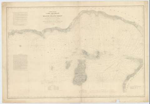
Título: North End of Lake Michigan Including the Beaver Island Group / From Trigonometrical Surveys under the direction of the Topographical Bureau of the War Department... under the orders of Captain J.N. Macomb Topographical Engineers in 1854 & 1855 ; Reduced Drawing by J.U. Mueller Assistant U.S.L.S. ; Engraved by W.H. Dougal
Área de datos: Escala 1:120000 (O 86°12'15''--O 84°50'00''/N 46°08'00''--N 45°29'30'')
Publicación: [Washington] : Bureau of Topographical Engineers of the War Department, [1857]
Descripción física: 1 carta náutica <, 60 x 90 cm ; 60 x 90 cm
Tipo de contenido: Imagen cartográfica
Tipo de medio: computadora
Tipo de soporte: recurso en línea
Serie: (Survey of the Northern and North Western Lakes)
Notas: Escala también dada en formas gráficas de 20000 yardas y 10 millas legales inglesas. Orientado con dos nudos de rumbos, en los que se señala además la variación magnética observada
Relieve por normales
Fecha de publicación tomada del sello del editor
Indica sondas batimétricas y veriles, así como las líneas de derrota a seguir para recorrer el lago
Clave hidrográfica para determinar la calidad del fondo
Tabla que recoge la variación magnética en varios puntos del área representada, además de los faros y del nivel del mar en diferentes años
En nota se informa sobre las características de esta parte del lago
En otra nota se señala todos aquellos trabajos tenidos en cuenta para la elaboración del presente documento
Materia / lugar / evento: Cartas náuticas
Batimetría
Lagos
1857
Otros autores: Macomb, J. N
Dougal, W. H
Mueller, J. U
Estados Unidos. War Department. Engineer Bureau
CDU: 774-191.2
Tipo de publicación:
Mapas
Derechos:
Préstamo:
Disponible
