Map of the Country betwen Millikens Bend, La. and Jackson...


 Mapas, planos y cartas náuticas
Map of the Country betwen Millikens Bend, La. and Jackson, Miss. : shewing the Routes followed by the Army of the... (1876)
Mapas, planos y cartas náuticas
Map of the Country betwen Millikens Bend, La. and Jackson, Miss. : shewing the Routes followed by the Army of the... (1876)
 Disponible Ejemplares
 Sección: Mapas, planos y cartas náuticas
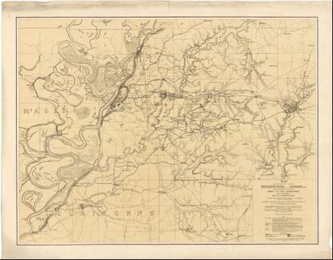
Título: Map of the Country betwen Millikens Bend, La. and Jackson, Miss. : shewing the Routes followed by the Army of the Tennessee under the command of Maj. Genl. U.S. Grant, U.S. vols. in its March from Millikens Bend to the Rear of Vicksburg in April and May 1863 / Compiled, surveyed and drawn under the Direction of Lt. Col. Js. H. Wilson, A.I. Grs. & 1st. Lt. Engrs ; Drawn by Maj. O.H. Matz, Asst. Eng. & 1st. Lt, L. Helmle, 3d. M° Vols. Inft. ; Surveys by 1st. Lt. P.C. Hains [et al.]
Área de datos: Escala [ca. 1:129000]
Publicación: [Washington] : Published by authority of the Hon. the Secretary of war, Office of the Chief of Enginneers U.S. Army, 1876
Descripción física: 1 mapa : col. ; 67 x 89 cm
Tipo de contenido: Imagen cartográfica
Tipo de medio: computadora
Tipo de soporte: recurso en línea
Notas: Comprende la franja de terreno comprendido entre los márgenes del rio Mississippi y la ciudad de Jackson, al O. del estado, que muestra las posiciones de las fuerzas confederadas y de la Unión, las fortificaciones defensivas de las primeras y el itinerario seguido por las segundas
Escala nominal de media pulgada por cada milla
Relieve representado por normales
Clave de símbolos
Leyenda explicativa de las características geográficas de la región
Impreso en rojo lo referente al ejército confederado y azul para el estadounidense
Materia / lugar / evento: Operaciones bélicas
Mapas topográficos
Estrategia militar
Fortificaciones
1876
Otros autores: Hains, P. C
Matz, Otto H
Wilson, H Cartógrafo
Helmle, L
Estados Unidos. War Department
Estados Unidos. Army. Office of the Chief of Engineers
CDU: 912:355.4:355.43(768-15)"1863"
768-15
Tipo de publicación:
Mapas
Derechos:
Préstamo:
Disponible
