Map of Pennsylvania : Exhibiting not only the Improved...


 Mapas, planos y cartas náuticas
Map of Pennsylvania : Exhibiting not only the Improved Parts of that Province, but also its extensive Frontiers ;... (1778)
Mapas, planos y cartas náuticas
Map of Pennsylvania : Exhibiting not only the Improved Parts of that Province, but also its extensive Frontiers ;... (1778)
 Disponible Ejemplares
 Sección: Mapas, planos y cartas náuticas
Título uniforme: PENSILVANIA (Estados Unidos). Mapas generales (1770 (1778). 1:375000
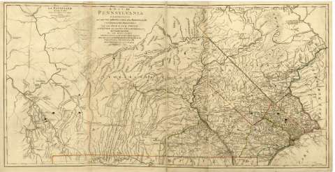
Título: Map of Pennsylvania : Exhibiting not only the Improved Parts of that Province, but also its extensive Frontiers ; laid down from actual surveys and chiefly from the late map of W. Scull published en 1770 / and humbly inscribed to the Honorable Thomas Penn and Richard Penn Esquires true and absolute propietaries & Governors of the Province of Pennsylvania and territories therennto belonging
Área de datos: Escala [ca. 1:375000]
Publicación: A Paris : Chéz le Rouge, rue des Grands Augustins avec Privilege du Roi, [1778]
Descripción física: 1 mapa en 3 h. : col., montado sobre tela ; 67 x 132 cm
Tipo de contenido: Imagen cartográfica
Tipo de medio: computadora
Tipo de soporte: recurso en línea
Notas: Escalas gráficas de 30 millas inglesas de 691 al grado [= 12,9 cm] de 10 leguas marinas [= 14'8 cm] y de 30 millas [= 12,9 cm]. Coordenadas referidas al meridiano de Londres (O 79°50'-O 74°15'/N 41°48'-N 39°37')
Relieve de perfil
Fecha de publicación tomada de: "Tooley's Dictionary of Mapmakers", p. 572
Figura el título también en francés: "La Pensilvanie : en trois feuilles ; traduitedes meilleures cartes anglaises"
Señala coloreados los límites entre los condados
Materia / lugar / evento: Mapas generales
Divisiones administrativas
1778
Otros autores: Scull, William
Le Rouge, George-Louis, 1712-ca. 1790
CDU: 748
Tipo de publicación:
Mapas
Derechos:
Préstamo:
Disponible
