Map of Central America : including the states of...


 Mapas, planos y cartas náuticas
Map of Central America : including the states of Guatemala, Salvador, Honduras, Nicaragua & Costa Rica, the... (1853)
Mapas, planos y cartas náuticas
Map of Central America : including the states of Guatemala, Salvador, Honduras, Nicaragua & Costa Rica, the... (1853)
 Disponible Ejemplares
 Sección: Mapas, planos y cartas náuticas
Título uniforme: AMERICA CENTRAL. Mapas generales (1853). 1:2100000
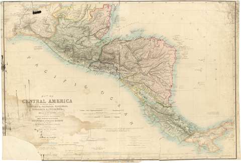
Título: Map of Central America : including the states of Guatemala, Salvador, Honduras, Nicaragua & Costa Rica, the territories of Belise & Mosquito, with parts of Mexico, Yucatan & New Granada : shewing the proposed routes between the Atlantic & Pacific Oceans by way of Thehuantepeque, Nicaragua & Panama / Engraved from the Original Drawing of John Baily Esq. R.M. of Guatemala ; with additions from the latest surveys of the Admirlty, S. Moro, col. LLoyd, Garella &
Área de datos: Escala [ca. 1:2100000 ; proy. Mercator] (O 96°00'--O 79°00'/N 18°30'--N 7°00')
Publicación: London: Published by Saunders and Stanford, 6, Charing Cross, 1853
Descripción física: 1 mapa : col. ; 64 x 93 cm
Tipo de contenido: Imagen cartográfica
Tipo de medio: computadora
Tipo de soporte: recurso en línea
Notas: Existe una edición posterior, de 1856, en la signatura SGE J-4-1-17(6)
Escala gráfica de 200 millas geográficas de 60 en grado [= 17,6 cm] y además de 200 millas estatuarias [= 15,3 cm] y 70 leguas de Castilla [= 14,1 cm]. Red geográfica de 1° en 1°
Relieve representado con normales y puntes acotados expresados en pies
En el margen izquierdo aparece una nota relativa a las divisiones administrativas de Méjico y en el margen derecho otra relacionada con el nivel del mar de ambos océanos
Con cuatro perfiles longitudinales del terreno existente entre el lago Nicaragua y el océano Pacífico, o bien entre éste y el océano Atlántico, correspondientes a rutas de navegación ejecutadas por diversos geógrafos, con el nombre de éstos y fecha del reconocimiento. Los perfiles son los siguientes: Lago Nicaragua-Lago de Managua-Realejo; Lago Nicaragua-Río Sapoa- Océano Pafífico; Canal de Panamá; Puerto de San Juan de Nicaragua-Lago Nicaragua-Puerto de San Juan. Su reccorrido se halla marcado sobre el plano. Entodos ellos se indica la altura de las aguas y del terreno y distancias
Países diferenciados por colores
Materia / lugar / evento: Navegación marítima
Mapas generales
Perfiles
Otros autores: Baily, John
Moro, S
Lloyd
Garella
Sauders and Stanford (Londres)
CDU: 912:656.61]:744.4(728)"1853"
728
Tipo de publicación:
Mapas
Derechos:
Préstamo:
Disponible
