Map exhibiting part of the operations of the Army of...


 Mapas, planos y cartas náuticas
Map exhibiting part of the operations of the Army of Virginia under the command of Major General John Pope. :... (1862?)
Mapas, planos y cartas náuticas
Map exhibiting part of the operations of the Army of Virginia under the command of Major General John Pope. :... (1862?)
 Disponible Ejemplares
 Sección: Mapas, planos y cartas náuticas
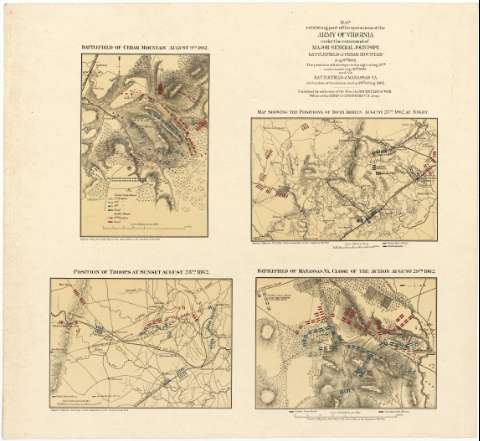
Título: Map exhibiting part of the operations of the Army of Virginia under the command of Major General John Pope. : Battlefield of Cedar Mountain Aug. 9th 1862 the positions of the troops on the night of Aug. 27 th. and at sunset Aug. 28 th. 1862 and the Battlefield of Manassas Va at the close of the Action on the 19 th. of Aug. 1862 / Published by authority of the Hon. the Secretary of War Office of the Chief of Engineer, U.S. Army
Área de datos: Escalas dif
Publicación: [Washington] : Secretary of War, Office of the Chief of Engineers U.S. Army, 1862?
Descripción física: 4 mapas en 1 hoja : col. ; 16 x 22 o menor, hoja de 53 x 58 cm
Tipo de contenido: Imagen cartográfica
Tipo de medio: computadora
Tipo de soporte: recurso en línea
Notas: Consta de los siguientes mapas: "Batterfield of Cedar Mountain August 9th.1862".- Escala [ca. 1:32000], 2 millas [= 10 cm]. "Map showing the Positions of Both Armies August 27th. 1862 at night". Escala [ca. 1:193000], 6 millas [= 5 cm]. "Position of Troops at Sunset August 28th. 1862". Escala [ca. 1:134000], 4 millas [= 4'8 cm]. Y "Battlefield of Manassas, Va. close of Action August 29th. 1862". Escala [ca. 1: 26000], 2 millas [= 12'4 cm].
Figuran las escalas nominales de cada uno de los mapas, expresadas en pulgadas por milla. Orientados con flechas
Orografía de perfil
Indica las posiciones de ambas tropas, (color rojo para las fuerzas rebeldes y azul para los estadounidenses), con los nombres de los oficiales que las comandaron
Al pie de cada mapa aparece impreso "Report of Maj. Gen. John Pope to the Committee on the Conduct of the War"
Materia / lugar / evento: Operaciones bélicas
Estrategia militar
Otros autores: Estados Unidos. War Department
Estados Unidos. Army. Office of the Chief of Engineers
CDU: 912:355.4:355.43(755-18)"1862"
755-18
Tipo de publicación:
Mapas
Derechos:
Préstamo:
Disponible
