A New Map of North America where in the British Dominions...


 Mapas, planos y cartas náuticas
A New Map of North America where in the British Dominions in the Continet of North America and on the Island of West... (1763)
Mapas, planos y cartas náuticas
A New Map of North America where in the British Dominions in the Continet of North America and on the Island of West... (1763)
 Disponible Ejemplares
 Sección: Mapas, planos y cartas náuticas
Título uniforme: AMERICA. Mapas generales (1763). 1:5300000
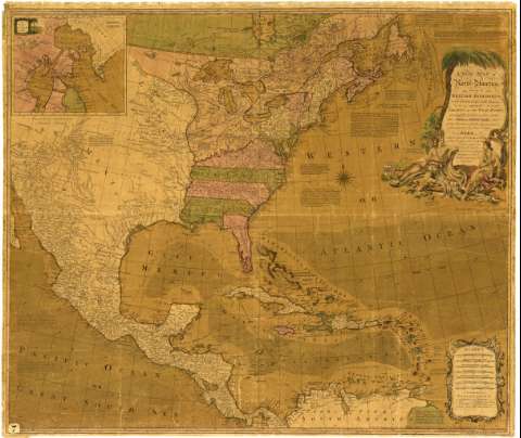
Título: A New Map of North America where in the British Dominions in the Continet of North America and on the Island of West Indies : are carefully laid down from all the Surveys, hitherto made, and the Boundaries of the New Goverwnments, as well as the other Provinces, are shaw : Also Extracts from the Definitive Treaty of Peace in 1763, relative to the Cessions made to his Britannick Majesty on the Continet of North America and the Partition agree on for the Islands / this map is laid down by Delarochette ; and Engraved by Tho. Kitchin
Área de datos: [Ca. 1:5300000]
Publicación: London : Printed for John Bowles at N 13 in Cornhill, 1763
Descripción física: 1 mapa : col., montado sobre tela ; 101 x 105 cm, pleg. en 103 x 61 cm
Tipo de contenido: Imagen cartográfica
Tipo de medio: computadora
Tipo de soporte: recurso en línea
Notas: Comprende desde la costa septentrional de América del Sur hasta la Bahía James
Escala gráfica de 240 millas geométricas de 60 al grado [= 8,4 cm] y además de millas estatuarias, leguas comunes francesas, leguas españolas de 19 al grado, leguas marinas e inglesas de 20 al grado, leguas marinas españolas de 17 al grado y leguas de camino. Coordenadas referidas al meridiano de Hierro (O 100°00'-O 25°00'/N 50°00'-N 5°00'), y Londres ( O 15°00'-O 45°00'/N 50°00'-N 05°00'). Red geográfica de 5° en 5°
Orientado con lis en rosa de 16 vientos
Relieve de perfil
Leyendas explicativas sobre los límites que se propusieron en la Paz de 1763, los cuales se hallan reflejados por medio de colores
Relación de las posesiones pertenecientes a Inglaterra, Francia, España, Holanda y Dinamarca, indicadas mediante distintos colores y clave alfabética
Indica las corrientes marinas en el Mar Caribe y Golfo de México, así como las derrotas más usuales entre Veracruz y La Habana, Cartagena y La Habana y Cartagena de Indias y España
Título enmarcado en cartela decorada con motivos indígenas y ornamentos de carácter arquitectónico para las escalas
Inserta: "A map of the Bays of Hudson and Baffin". Escala [ca. 1:16700000], de 300 millas inglesas de 691 al grado [= 2,9 cm] y de 100 leguas francesas de 25 al grado [= 3,2 cm]. Coordenadas referidas al meridiano de Hierro (O 90°00'00''-O 05°00'00''/N 70°00'00''-N 55°00'00')
Materia / lugar / evento: Mapas generales
Colonias
Divisiones administrativas
Tratados
Derroteros
Costas
Bahías
Mares
Corrientes oceánicas
Fronteras
1763
Caribe (Mar)
Venezuela
México
América
Otros autores: La Rochette, Louis Stanislas D'Arcy de
Bowles, John
Kitchin, Thomas
CDU: (7)
Tipo de publicación:
Mapas
Derechos:
Préstamo:
Disponible
