Battlefield in front of Franklin, Tenn. where the United...


 Mapas, planos y cartas náuticas
Battlefield in front of Franklin, Tenn. where the United States Forces, consisting of the 4th & 23d Corps and the... (1874)
Mapas, planos y cartas náuticas
Battlefield in front of Franklin, Tenn. where the United States Forces, consisting of the 4th & 23d Corps and the... (1874)
 Disponible Ejemplares
 Sección: Mapas, planos y cartas náuticas
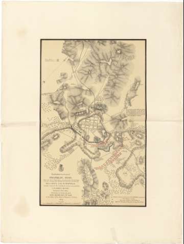
Título: Battlefield in front of Franklin, Tenn. where the United States Forces, consisting of the 4th & 23d Corps and the Calvary Corps M.D.M., all under the command of Maj. Gen'l J.M. Shofield, severely repulsed the Confederate Army, Commanded by Lt. Gen'l Hoad November 30th 1864 / Published by Authority of the Hon. Secretary of War in the Office of the Chief of Engineers, U.S. Army 1874 ; Compiled under the direction of Col. W.E. Merrill, chief Eng. D.C. from Surveys made by Maj. James R. Willett, 1st U.S.V.V. Engs & Maj. T.J.L. Remington 74th Reg. I.U.V.I Chief T.E. 4 th A.C
Área de datos: Escala [ca. 1:11000]
Publicación: [Washington] : Secretary of War, Office of the Chief of Engineers U.S. Army, 1874
Descripción física: 1 map : col. ; 70 x 45 cm
Tipo de contenido: Imagen cartográfica
Tipo de medio: computadora
Tipo de soporte: recurso en línea
Notas: Presenta el plano de la ciudad de Franklin y parte de sus alrededores, indicando la posición que ocuparon en dicha zona los contendientes en la Guerra de Secesión (línea roja para los confederados y azul para las tropas federales)
Escala gráfica de 1 milla [= 15 cm]. Orientado con flecha
Orografía por normales
Materia / lugar / evento: Operaciones bélicas
Mapas topográficos
Planos de población
Estrategia militar
1864
Tennessee
Franklin
Otros autores: Willett, James R
Remington, T.J.L
Merrill, W. E
Estados Unidos. War Department
Estados Unidos. Army. Office of the Chief of Engineers
CDU: 912:355.4:355.43:314(084.3)(768)"1864"
768 Franklin
Tipo de publicación:
Mapas
Derechos:
Préstamo:
Disponible
