A Map of the Island of St. John : in the gulf of St....


 Mapas, planos y cartas náuticas
A Map of the Island of St. John : in the gulf of St. Laurence... (1775?)
Mapas, planos y cartas náuticas
A Map of the Island of St. John : in the gulf of St. Laurence... (1775?)
 Disponible Ejemplares
 Sección: Mapas, planos y cartas náuticas
Título uniforme: SAINT JOHN (Canadá) (Isla). Parcelación del suelo (1775?). 1:308642
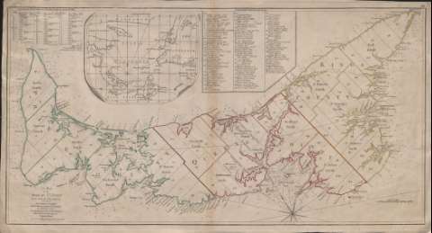
Título: A Map of the Island of St. John : in the gulf of St. Laurence... / Improv'd from the late Survey of Captain Holland
Área de datos: Escala [ca. 1:308.642]. 10 millas marinas inglesas [= 6 cm]
Publicación: London, no. 53 Fleet Street : Printed for Robt. Sayer, [1775?]
Descripción física: 1 mapa : col. ; 36 x 69
Tipo de contenido: Imagen cartográfica
Tipo de medio: computadora
Tipo de soporte: recurso en línea
Notas: Coordenadas en latitud 46°30'. Orientado con rosa de 8 vientos y lis
Indica sondas batimétricas
Fecha de publicación tomada del Tooley's Dictionary of Mapmakers, p. 561
Figura índice de la parcelación del suelo con nombres y apellidos de sus propietarios
Señala en tinta amarilla, roja y verde sólo el borde costero y las divisiones administrativas
En el ángulo superior izquierdo, clave numérica referente a ciudades y extensión en acres de cada división administrativa de la isla
Inserta: "Mapa del golfo de San Lorenzo". Coordenadas referidas al meridiano de Londres (O 65°-O 56°/N 50°-N 46°). Orientado con nudo de rumbos y lis
Materia / lugar / evento: Parcelación
Divisiones administrativas
San Lorenzo
Canadá
Otros autores: Holland, Samuel
Sayer, Robert, 1725-1794
CDU: 71 Saint John
Tipo de publicación:
Mapas
Derechos:
Préstamo:
Disponible
