Preliminary Chartof the West End of Fond du lac of Lake...


 Mapas, planos y cartas náuticas
Preliminary Chartof the West End of Fond du lac of Lake Superior : embracing Superior. St. Louis and Allovez Bays... (1863)
Mapas, planos y cartas náuticas
Preliminary Chartof the West End of Fond du lac of Lake Superior : embracing Superior. St. Louis and Allovez Bays... (1863)
 Disponible Ejemplares
 Sección: Mapas, planos y cartas náuticas
Título uniforme: SUPERIOR (Estados Unidos) (Lago). Cartas náuticas. 1863 (1861). 1:32000
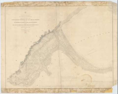
Título: Preliminary Chartof the West End of Fond du lac of Lake Superior : embracing Superior. St. Louis and Allovez Bays and the St. Louis River to the Head of Navigation / Projected from a Trigonometrical Survey executed under the orders of Capt. Geo. G. Meade. Top. Engrs. in 1861 ; Reduced for engraving under the direction of col. J.D. Graham U.S. Eugrs. in 1863 ; Made in obedience to acts of Congress and under the direction of the Bureau of Topographical Engineers Department ; Engraved by W.H. Dougal
Área de datos: Escala 1:32000
Publicación: [Washington] : Bureau of Topographical Engineers of the War Department, 1863
Descripción física: 1 carta náutica ; 70 x 92 cm
Tipo de contenido: Imagen cartográfica
Tipo de medio: computadora
Tipo de soporte: recurso en línea
Serie: (Survey of the Northen and North Western Lakes)
Notas: Escala también dada en formas gráficas de 11000 yardas y 7 millas legales inglesas. Orientado con tres nudos de rumbos, en los que se señala además la variación magnética observada
Relieve por normales
Indica sondas batimétricas y veriles, así como las líneas de derrota a seguir para recorrer esta parte del lago
Clave hidrográfica para determinar la calidad del fondo
Toponimia costera de los principales accidentes geográficos y núcleos de población más significativos
En nota se informa sobre las características de la zona representada
En otra nota se señalan todos aquellos trabajos tenidos en cuenta para la elaboración del presente documento
Materia / lugar / evento: Cartas náuticas
Batimetría
Lagos
1861
1863
Saint Louis (Río)
Otros autores: Meade, George G
Dougal, W. H
Graham, James Duncan
Estados Unidos. War Department. Engineer Bureau
CDU: 776-11
775-17
Tipo de publicación:
Mapas
Derechos:
Préstamo:
Disponible
