Section of map of parts of Brunswick and New Hanover...


 Mapas, planos y cartas náuticas
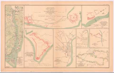
Section of map of parts of Brunswick and New Hanover Counties Showing the approaches to Wilmington, N.C. (189-?)
Mapas, planos y cartas náuticas
Section of map of parts of Brunswick and New Hanover Counties Showing the approaches to Wilmington, N.C. (189-?)
 Disponible Ejemplares
 Sección: Mapas, planos y cartas náuticas
Título uniforme: CAROLINA DEL NORTE (Estados Unidos). NE. Maniobras de campaña. 189 (1861-1865). 1:120700
Título: Section of map of parts of Brunswick and New Hanover Counties Showing the approaches to Wilmington, N.C. / made under the direction of Capt. W.H. James, Ch. Engr. by B.L. Blackford, 1st Lieut. Engrs.
Área de datos: Escala [ca. 1:120700], 3 miles [= 4 cm]
Publicación: Washington : Government Printing Office, [189-?] (N.Y. [Nueva York] : Julius Bien & co.)
Descripción física: 1 mapa : col. ; 42x13 cm, en h. de 47x75 cm
Tipo de contenido: Imagen cartográfica
Tipo de medio: computadora
Tipo de soporte: recurso en línea
Notas: En : Atlas to accompany the Official Records of the Union and Confederate Armies 1861 - 1865. - Plate CXXXII, n 1
Relieve : líneas perpendiculares normales
Figura en margen inferior : Series I. Vol. XLVL. Page 434
Orientado con flecha
Representadas mediante color rojo las posiciones del ejército confederado
En : Atlas to accompany the Official Records of the Union and Confederate Armies 1861 - 1865
Materia / lugar / evento: Guerra civil
Maniobras de campaña
Itinerarios
Fortalezas militares
Redes de transporte
Planos de población
S.XIX
Brunswick (Condado)
New Hanover (Condado)
Wilmington
Estados Unidos
Otros autores: Blackford, B.L
James, W. H
CDU: 912:355.4]:[355.52+656.02+623.1](756-18)'1861/1865'
912:314(756 Wilmington)(084.3)
756-18
Tipo de publicación:
Mapas
Derechos:
Préstamo:
Disponible
