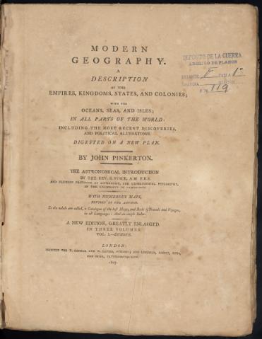
Modern Geography : a description of the empires, kingdoms...
Sección: Mapas, planos y cartas náuticas
Título uniforme: América. Mapas generales. 1807
Título: Modern Geography : a description of the empires, kingdoms, states, and colonies, with the oceans, seas, and isles, in all parts of the world : including the most recent discoveries and political alternations Digested on a new plan / by John Pinkerton ; the astronomical introduction by the Rev. S. Vince, A.M. F.R.S. and Rumian professor of astronomy, and experimental philosophy in the University of Cambridge
Edición: A new edition, gleatly enlarged
Área de datos: Varias escalas
Publicación: London : printed for T. Cadell and W. Davies, Strand : and Longman, Hurst, Rees and Orme, Paternoster Row, 1807
Descripción física: 1 atlas (2 v.) (CXXIX, 739 p., 1006 p.) : 39 mapas ; 30,5 cm
Tipo de contenido: Imagen (cartográfica ; fija ; bidimensional ; visual)
Tipo de medio: sin mediación
Notas: Atlas en 3 volúmenes de los que sólo se conservan 2 que contienen 39 de mapas de Europa, Africa y América
El meridiano de origen utilizado es Greenwich
Relieve representado por normales
Además de la introducción astronómica tiene amplias explicaciones de las zonas representadas en los mapas sobre datos geográficos, fauna, costumbres, historia, demografía, religión, divisiones administrativas y eclesiásticas, leyes, ejército, cultura, economía y colonias
Presenta índices de los mapas incluídos, y uno toponímico al final del vol. III, así como un catálogo de mapas y libros de viajes
Encuadernación forrada con tela y lomos y esquinas con piel verde
Ejemplares deteriorados
Contenido incompleto: Vol. I: Europe: 1. The world ; 2. Europe ; 3. United Kingdoms of Great Britain and Ireland ; 4. England and Wales ; 5. Remote British isles ; 6. Scotland ; 7. Ireland ; 8. France ; 9. Netherlands ; 10. Russia in Europe ; 11. Austrian dominions ; 12. Prussian states ; 13. Spain and Portugal ; 14. Turkey in Europe ; 15. Greece ; 16. Holland ; 17. Denmark ; 18. Switzerland ; 20. Germany, North of the Mayn ; 21. Germany, South of the Mayn ; 22. Italy. Vol. III : America and Africa: 1. North America ; 2. United States of North America ; 3. Spanish dominions in North America ; 4. British Possessions in America ; 5. West Indies ; 6. South America ; 7. Viceroyalty of La Plata ; 8. Viceroyalty of Peru ; 9. Viceroyalty of New Granada ; 10. Government of Caracas, with Guiana ; 11. Chili ; 12. Africa ; 13. Egypt; 14. West Africa ; 15. Colony of the Cape of Good Hope ; 16. East Africa ; 17. Center of Northern Africa from Ptolomey. From the arabs, & c
Otros autores: Pinkerton, John, 1758-1826
Vince, Samuel, 1749-1821
Cadell & Davies
Longman, Hurst, Rees & Orme (Londres)
CDU: 912:311.2(084.4)(7/8)"1807"
7/8
4
6
Tipo de publicación:
![]() Mapas
Mapas
Préstamo:
![]() Disponible
Disponible
Préstamo:
![]() Disponible
Disponible


