The Mahé islands : in the Indian ocean 180 leagues to the...


 Mapas, planos y cartas náuticas
The Mahé islands : in the Indian ocean 180 leagues to the north east of Madagascar, Geometrically surveyed in the... (1778)
Mapas, planos y cartas náuticas
The Mahé islands : in the Indian ocean 180 leagues to the north east of Madagascar, Geometrically surveyed in the... (1778)
 Disponible Ejemplares
 Sección: Mapas, planos y cartas náuticas
Título uniforme: Mahe (Seychelles). Isla de. Cartas náuticas. 1778 (1768). 1:213000
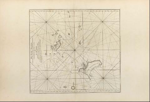
Título: The Mahé islands : in the Indian ocean 180 leagues to the north east of Madagascar, Geometrically surveyed in the year 1768 [Mapa] / by L'Abbe Rochon, with the Tracks and soundings of several vesselschiesly of the Flute la Dique and the Schooner la Curiense; from a drawing communicated by Capt John Hassell of the Duke of Portland
Área de datos: Escala [ca. 1:213000]
Publicación: London : Robert Sayer and John Bennett, 1778
Descripción física: 1 map. ; 54 x 50 cm
Notas: En : "The East India Pilot or oriental Navigator", part. I, map. n° 36
Graduado únicamente en latitud
Consta escala gráfica de 20 leguas inglesas y francesas, de veinte al grado, de 51,3 cm de longitud
Aparece trazado el meridiano de Seychelles
Orientado con lis
Presenta líneas de derrota de la expedición de la Dique y la Curiense
Materia / lugar / evento: Cartas náuticas
Islas
Otros autores: l'Abbe Rochon
Bennett, John
Sayer, Robert, 1725-1794
Hassell, John
CDU: 912:551.46]:551.42+910.4:527.6(696:22)"17"
696:22 Mahe
Tipo de publicación:
Mapas
Derechos:
Préstamo:
Disponible
