Sketch of the Navigation throught East Neebish Rapids :...


 Mapas, planos y cartas náuticas
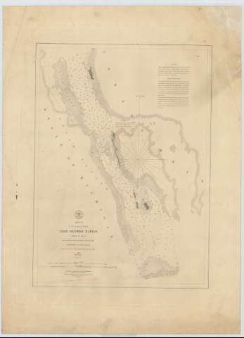
Sketch of the Navigation throught East Neebish Rapids : River St. Mary (1854)
Mapas, planos y cartas náuticas
Sketch of the Navigation throught East Neebish Rapids : River St. Mary (1854)
 Disponible Ejemplares
 Sección: Mapas, planos y cartas náuticas
Título uniforme: SAINT MARYS (Estados Unidos) (Michigan) (Río). Cartas náuticas. 1854 (1853). 1:15000
Título: Sketch of the Navigation throught East Neebish Rapids : River St. Mary / From Surveys by Capt. E.P. Scammon Corps Topl. Engrs., W.H. Hearding and C.S. Cole Assistant under the direction of Capt. J.N. Macomb Corps Topl. Engrs. 1853 ; Reduced for engraving by F. Herbst Draughtsman ; Engraved by W.H. Dougal under the direction of Capt. T.J. Lee Corps Topl. Engrs. Washington February 1854
Área de datos: Escala 1:15000
Publicación: [Washington : Bureau of Topographical Engineers of the War Department], 1854
Descripción física: 1 carta náutica ; 49 x 36 cm
Tipo de contenido: Imagen cartográfica
Tipo de medio: computadora
Tipo de soporte: recurso en línea
Serie: (Survey of the Northern and North Western Lakes)
Notas: Comprende los rápidos East Neebisch del río St. Mary entre el estado de Michigan y la provincia de Ontario
Escala también dada en formas gráficas de 2000 yardas y 1'5 millas legales. Orientado con nudo de treintaidos rumbos la que señala además la variación magnética observada
Relieve por normales
Indica sondas batimétricas y veriles, así como las distintas líneas de derrota a seguir para navegar por estos
Clave hidrográfica para determinar la calidad del fondo
En nota se explican las líneas de derrota aconsejadas para navegar por el río St. Mary
Materia / lugar / evento: Cartas náuticas
Batimetría
1853
1854
St. Mary (Canada)>(Río)
Otros autores: Scammon, E.P
Dougal, W. H
Hearding, W.H
Cole, C.S
Macomb, J. N
Herbst, F
Lee, T.J
Estados Unidos. War Department. Engineer Bureau
CDU: 774-12
713-14
Tipo de publicación:
Mapas
Derechos:
Préstamo:
Disponible
