Sketch of the Yellowstone Lake, and the Valley of the...


 Mapas, planos y cartas náuticas
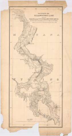
Sketch of the Yellowstone Lake, and the Valley of the upper Yellowstone River (1871?)
Mapas, planos y cartas náuticas
Sketch of the Yellowstone Lake, and the Valley of the upper Yellowstone River (1871?)
 Disponible Ejemplares
 Sección: Mapas, planos y cartas náuticas
Título: Sketch of the Yellowstone Lake, and the Valley of the upper Yellowstone River / route of Capt's J.W. Barlow and D.P. Heap corps of engineers in their reconnoissance of the that region during the summer of 1871 ; engraved at Headquarters Corps of Engineers War Departament
Área de datos: Escala 1:500000 (O 111°00'--O 110°00'/N 45°45'--N 44°00')
Publicación: [Washington? : Headquarters Corps of Engineers War Department?, 1871?]
Descripción física: 1 mapa ; 70 x 30 cm
Tipo de contenido: Imagen cartográfica
Tipo de medio: computadora
Tipo de soporte: recurso en línea
Notas: Comprende la parte noroccidental del estado norteamericano de Wyoming
Escala también dada en forma gráfica de 1 pulgada
Relieve por normales. Isolíneas batimétricas
Otros autores: Barlow, J.W
Heap, D.P
Estados Unidos. Army. Corps of Engineers
CDU: 787.16
Tipo de publicación:
Mapas
Derechos:
Préstamo:
Disponible
