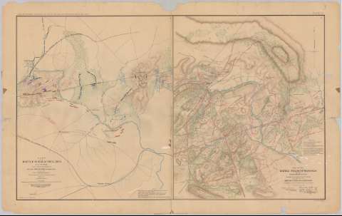
Plan of the battle - field at Bull Run, July 21st. 1861...


 Mapas, planos y cartas náuticas
Plan of the battle - field at Bull Run, July 21st. 1861 : to accompany the report of Brig. Gen. Irvin Mc. Dowell,... (189-?)
Mapas, planos y cartas náuticas
Plan of the battle - field at Bull Run, July 21st. 1861 : to accompany the report of Brig. Gen. Irvin Mc. Dowell,... (189-?)
 Disponible Ejemplares
 Sección: Mapas, planos y cartas náuticas
Título uniforme: BULL RUN (Estados Unidos) (Virginia). Batallas. 1890 (1861). 1:36576
Título: Plan of the battle - field at Bull Run, July 21st. 1861 : to accompany the report of Brig. Gen. Irvin Mc. Dowell, Commanding / prepared by Cart. A.W. Whipple, top. engns. ; 1st Lieut. H.L. Abbot ; 1st. Lieus. H.S. Potnam ; drawn by J.J. Young civil engineer
Área de datos: Escala [ca. 1:36576], 2 miles [= 8'8 cm]
Publicación: Washington : Government Printing Office, [189-?] (N.Y. [Nueva York] : Julius Bien & co.)
Descripción física: 1 mapa : col. ; 41x35 cm, en h. de 47x75 cm
Tipo de contenido: Imagen cartográfica
Tipo de medio: computadora
Tipo de soporte: recurso en línea
Notas: En : Atlas to accompany the Official Records of the Union and Confederate Armies 1861 - 1865. - Plate III, n 1
Relieve : líneas perpendiculares normales
Nota relativa a las fuentes de información del mapa
Figura en el margen inferior : Series 1. vol. 2. page 317
En : Atlas to accompany the Official Records of the Union and Confederate Armies 1861 - 1865
Materia / lugar / evento: Guerra civil
Batalla de Bull Run
Estrategia militar
1861
Estados Unidos
Otros autores: McDowell, Irvin
Abbot, Henry L
Whipple, Amiel Weeks
Putnam, H.S
Young, J. J
CDU: 912:355.4]:[355.922+355.43](755 Bull Run)'1861'
755
Tipo de publicación:
Mapas
Derechos:
Préstamo:
Disponible
