The Southern countries of India from Madrass to Cape Comorin


 Maps, plans and nautical charts
The Southern countries of India from Madrass to Cape Comorin (1784?)
- Kelly, D
Maps, plans and nautical charts
The Southern countries of India from Madrass to Cape Comorin (1784?)
- Kelly, D
 Disponible Holdings
 Section: Maps, plans and nautical charts
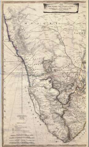
Title: The Southern countries of India from Madrass to Cape Comorin / surveyed by Coll. Kelly, Capn. Wersebe and others
Author: Kelly, D
[The Southern countries of India from Madrass to Cape Comorin] All editions
Characteristics of the edition: 1784?. 1:720000. Español
Material or type of resouce Area: Escala [ca. 1:720.000]
Publication: [Gran Bretaña?]: Mr. Anquetil du Porron, [1784?]
Physical description: 1 mapa en 2 h. : col. ; 89 x 104 cm en h. de 91 x 55 cm
Content type: Imagen cartográfica
Media type: computadora
Carrier type: recurso en línea
Notes: Carta arrumbada
Carta arrumbada en la que se indican sondas batimétricas, veriles y bajos
En nota se señalan los trabajos en los que se han basado para la elaboración de este mapa
Escala gráfica de 60 millas estatutarias [= 13'5 cm]. Escalas gráficas de 60 minutos de latitud, 80 millas de 80 en grado y 40 millas de Malabar. Coordenadas referidas al meridiano de Londres (E 75°20'--E 81°40'/N 13°20'--N 13°20'). Recuadro geográfico de 30' en 30. Orientado con lis en rosa de ocho vientos
Orografía por normales
Tabla de signos convencionales para indicar las fortificaciones y núcleos de población mas importantes y relación de las posesiones españolas y francesas, y de las rutas de los distintos ejércitos entre 1781 y 1784, indicados por clave cromática
Título enmarcado en servilleta
Reproducción digital
Materia / lugar / evento: Divisiones administrativas
Cartas náuticas
Genre / form: Documentos archivísticos
Mapas generales
Other authors: Wersebe, Hermann Martin Christian von
Anquetil-Duperron, A. Hyacinthe
España. Dirección de Hidrografía. Expediciones a Indias, productor
Museo Naval (Madrid). Archivo. Documentos gráficos, Mapas
Type of publication:
Maps
Rights:
Préstamo:
Disponible
